|
Location
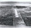
Lat 9° 5' 12S Long 143° 12' 28E Daru Airfield is located on Daru Island.
World War II Pacific Theatre History
Small Allied wartime
airstrip, used as part of the ferry route from Horn
Island Airfield, to Port Moresby. The offshore area was used as a seaplane landing area.
Postwar
During 1965, the Australian Army undertook the reconstruction of Daru Airfield.
Today
Still in use
today as "Daru Airport". The runway measures 1,400m x 30m orientation 14 / 32 at an elevation of 13'. Airport codes: ICAO: AYDU and IATA: DAU.
References
NAA: BP456/2, 1965/68 PART 1 Daru - Reconstruction of airfield
NAA: BP456/2, 1965/68 PART 2 Daru - Reconstruction of airfield
National Airport Comission (NAC) - Daru Airport
Contribute
Information
Do you have photos or additional information to add?
Last Updated
April 19, 2021
|