|
|
|
|
| Missing In Action (MIA) | Prisoners Of War (POW) | Unexploded Ordnance (UXO) |
| Chronology | Locations | Aircraft | Ships | Submit Info | How You Can Help | Donate |
|
 Catholic Church c1937 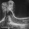 90th BG c1943 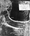 5th AF Sept 9, 1943 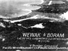 5th AF Nov 18, 1943 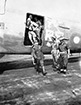 Australian Army September 13, 1945  Justin Taylan 2000  Justin Taylan 2003 |
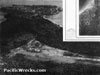
Location Wewak Airfield was located at Wirui to the southeast of Wewak Town (Wewak Point), parallel to the coast line. To the east is Mission Point and northeast is Wewak Harbor. Also known as "Wirui Drome", "Wewak Drome" or "Wewak Central". Prewar and during the Pacific War located in the Territory of New Guinea. Today located in Wewak District, East Sepik Province (ESP) in Papua New Guinea (PNG). Construction Prewar, this area was known as Wirui Plantation planted with coconut palms harvesting copra. During 1937, a small airfield was built at this location by the Australian administration and Catholic church, to provide air service for the Wewak area. By early 1942, the airfield was described as a single runway was 1,400 x 100 x 10 yards with prevailing winds NW-SE and good approaches. European houses, food and water were available. W. O. Jones was based at the airfield. World War II Pacific Theatre Wartime History By late 1942, most colonial officials and families fled the Wewak area, fearing a Japanese attack. On December 18, 1942 the Japanese Army landed at Wewak when four ships landed unopposed between 8pm and 2am unloading roughly 2,000 troops from the 20th Division and supplies onto the beach from Wewak to Wirui. Afterwards, troops used barges to move down the north coast to occupy Madang. On December 28, 1942 the 117th Airfield Survey and Construction Battalion began upgrading the civilian airfield for use by military aircraft, expanding the runway, facilities and adding a taxiway loop and dispersal area. On January 17, 1943 the first Japanese aircraft to arrive at Wewak Airfield was a detachment from the Junyō consisting of twenty-three A6M2 Zeros and six B5N2 Kates commanded by Lt Cdr Takashi Hashiguch supporting the aircraft were 120 ground personnel. These aircraft were part of Operation MV to provide convoy protection as part of Hei I. While operating from Wewak, the airfield was still in civilian configuration. While based at Wewak, the detachment claimed four B-24s shot down, one B-24 damaged and three B-24 probables plus uncertain results against submarines. They suffered two planes (possibly B5N2 Kates) lost, two Zeros missing and ten Zeros damaged before departing on January 24, 1943 to Kavieng Airfield. On February 19, 1943, a detachment from the Zuihō arrived from Kavieng Airfield including twenty A6M2 A6M2 and eight B5N2 Kates under the command of Lt Cdr Hideo Matsuda to provide convoy protection. On February 28, 1943 the detachment withdrew to Kavieng Airfield then on March 1-3, 1943 to Truk. Japanese Navy units based at Wewak Airfield (Wirui, Wewak Central) 117th Airfield Survey and Construction Battalion Dec 18, 1942 - ? Junyō detachment (23 x A6M2, 6 x B5N2 ) Kavieng arrives January 17, 1943–February 24, 1943 departs Kavieng Zuihō detachment (20 x A6M2, 8 x B5N2) Kavieng arrives February 19, 1943–February 28, 1943 departs Kavieng Japanese Army units based at Wewak 45th Sentai (Ki-48) 14th Sentai (Ki-21) 83rd Dokuritsu Chutai / 83rd Independent Air Chutai (Ki-51 Sonia) China April 1943 (detachment Madang) May 1943 Lae By October 19, 1943 the runway measured 4,000' in length with over a hundred revetments: fifteen for bombers to the northwest towards the Wewak Point and 88 revetments to the southeast for fighters. American missions against Wewak Airfield (Wirui, Wewak Central) December 30, 1942–September 8, 1944 Tachi-6 Radar Two 50Kw radar sets, range 200km located at Wewak, in the vicinity of Wirui. Under the control of the Japanese Army 4th Air Intel Unit. Operational orders of 248th Sentai showed they scrambled based on radar intelligence. Reference: Japanese Mono. #127 via Richard Dunn The Naval Land Unitt That Vanished In The Jungle (1995) by Tetsuo Watanabe page 56: "May 4, 1944 The Wewak Airfield was a frightful spectacle. It was totally destroyed by bombardment. Similarly countless remains of our ships were lying in the harbor." During May 1945, the Australian Army occupied the Wewak area. This airfield was repaired and used by the Royal Australian Air Force (RAAF) until the end of the war. On September 13, 1945 Imperial Japanese Army (IJA) 18th Army commander Lt General Hatazo Adachi with Captain Iwama, civilian interpreter and three officers were flown aboard a RAAF C-47 Dakota from No. 36 Squadron from Hayfield Airfield to Wewak Airfield. Next, the Japanese were transported by jeep to Cape Wom for the official surrender ceremony at 10:00am at Cape Wom Airfield. At 10:15am Adachi signed the instrument of surrender and handed over his sword in the presence of 3,000 troops drawn from various units of the Australian Army 6th Division. Afterwards, he attended meetings with Australian Army staff to discuss arrangements related to the surrender. Today Wewak Airfield was abandoned since the war as an airfield. Since this airfield is located nearest to Wewak Town, it has been heavily picked over in the decades and the few traces of the war remain. A road runs atop the former runway. Bomb craters are still visible in the area and a few bits of aircraft wreckage remain in the area, that have not been scrapped in the decades since the war. References "A Brief History of Wewak" by the Catholic church describes the construction of the airfield Notes about New Guinea airfields, recorded circa May - July, 1942 by Oliver C. Doan via Jean Doan research Edward Rogers Japanese Monograph 161 Thank to Richard Dunn for additional information Contribute
Information Last Updated
|
Topographic Map July 1944 View on Google Earth Photo Archive |
| Discussion Forum | Daily Updates | Reviews | Museums | Interviews & Oral Histories |
|