|
|
|
|
| Missing In Action (MIA) | Prisoners Of War (POW) | Unexploded Ordnance (UXO) |
| Chronology | Locations | Aircraft | Ships | Submit Info | How You Can Help | Donate |
|
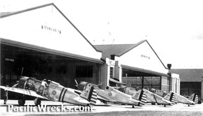 USAAF May 1941  USAAF December 7, 1941 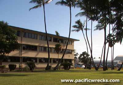 Justin Taylan 2004 |
Location Hickam Field is located to the west of Honolulu bordering Honolulu Airfield (John Rodgers Airfield) on Oahu in Hawaii in the United States. Hickam Field spanned from Bishop Point to the west and U.S. Naval Station Pearl Harbor and Pearl Harbor to the north. Fort Kamehameha is located to the south. Taxiways connect to Honolulu Airfield on the east. Extensive facilities included a hanger row and many buildings and support facilities. Today, part of Joint Base Pearl Harbor Hickam (JBPHH). Fort Kamehameha is located to the southwest bordering Holokahiki Point and Kamehameha Beach. Construction During 1935, a 2,200 acre site was purchased by the U.S. Army for a military airfield. Construction of the runway and base was completed by October 1939, at the time this was America's largest and most important base in Hawaii, and the newest and most modern airfield, capable of accommodating an air depot and a bombardment wing. The main runway measured 7,048' x 800' running roughly north-east to south-west. Also, there were three smaller runways in a triangular shape off the main runway: 4,725 x 250 and 4,025 x 250' and 4,630' x 250'. Naming Honors Named after aviation pioneer Lt. Col. Horace M. Hickam, who was killed in a flying accident on November 5, 1934 in Texas. Hickam Field was designated APO 953 (Army Post Office 953) between May 16, 1942 until May 31, 1946. Wartime History During October 1939 aircraft from the newly formed 5th Bombardment Group (5th BG) arrived from Luke Field. On November 1, 1940, the Hawaiian Air Force was activated with the 18th Bombardment Wing stationed at Hickam Field operating B-18 Bolos and B-17 Flying Fortresses. The Hawaiian Air Depot (HAD) was established at Hickam Field to reassemble aircraft, service aircraft, perform modifications and overhaul work required for any U.S. Army Air Force (USAAF) aircraft. During early 1942, the Commanding Officer (C.O.) was Lt. Col. Albert C. Boyd. On December 7, 1941 aircraft were parked wingtip to wingtip to protect them from sabotage. Attacking Japanese aircraft heavily damaged the base and destroyed parked planes. This airfield was used for the remainder of the Pacific War. American units based at Hickam 7th BG, 22nd BS air echelon (B-17) December 18, 1941 - January 5 1942 Singosari 7th BG, 88th BS air echelon (B-17) December 22, 1941 - February 10 1942 Fiji 7th Bomber Command, HQ activated at Hickam January 29, 1942 5th BG, 23rd BS (B-17) March 24, 1942 to Mokuleia 38th BG, 69th BS (B-26 air echelon) USA arrives May 22, 1942–June 17, 1942 departs New Caledonia 5th BG, 31st BS (B-18, B-18) May 23, 1942 to Kipapa 19th Transport Squadron (C-33 and C-53) departs May 29, 1942 to John Rodgers Airport 5th BG, 394th BS (B-17) ? - May 30, 42 Bellows returns July 24 - Sept 28, 42 Bellows 307th BG, 372nd BS (B-24) ? -June 13, 1943 departs Espiritu Santo 11th BG, HQ July 1942–November 9, 1943 returns April 8, 1943 11th BG, 98th BS (B-17) ? - August 11, 1942 Espiritu Santo 11th BG, 431st BS (B-17) departs November 11, 1943 Funafuti returns April 8, 1943 318th FG, HQ activated October 15, 1942–February 9, 1943 departs Bellows 41st BG, HQ from USA October 16, 1943 - December 17, 1943 Tarawa 30th BG, HQ USA arrives October 20, 1943–November 12, 1943 departs Nanumea 41st BG, 396th BS (B-25) from USA October 20 - December 24, 1943 Tarawa 41st BG, 820th BS (B-25) from USA October 20 - December 24, 1943 Tarawa 9th TCS (C-47) from US February 21 - March 27, 1944 Abemama 7th Fighter Command, HQ Fort Shafter October 20, 1944 - ? AAFPOA is activated at Hickam August 1, 1944 7th FW, 548th Night Fighter Squadron (P-61) ? - October 16, 1943 Kipapa 7th FW, 548th Night Fighter Squadron (P-61) from USA September 16, 1944 - ? 7th Fighter Command, HQ ? - January 18, 1945 Fort Kamehameha Flagpole Memorial The flagpole circle and memorial listing of all those who died at Hickam Field on December 7, 1941 with plaques for specific units including the 11th Bombardment Group (11th BG). The memorial includes a time capsule to be opened on December 7, 2041. In 2003, a bronze P-40 Warhawk dedicated to World War II aviators was added. Pacific Air Forces Headquarters Building Bullet holes are visible in the Pacific Air Forces HQ building. Inside is the US flag that flew over the base on December 7, 1941 and was also flown over the white house and present at the formal surrender of Japan. USAAC Hangers Heavily damaged in the attack, the four restored double hangers, with USAAC star above the doors are present today. Today Still in use today as Joint Base Pearl Harbor Hickam (JBPHH). Since September 11, 2001, Hickam is off limits to tourists for security reasons. Hickam AFB Museum 15th Air Base Wing Public Affairs, 800 Scott Circle, Hickam AFB B-25J Mitchell Serial Number 44-31504 Displayed at Hickam AFB outside the Pacific Air Forces HQ building between 1997–2004. Defense POW/MIA Accounting Agency (DPAA) 310 Worchester Ave, Bldg 45, Hickam, HI 96853 Department of Defense (DoD) Defense POW/MIA Accounting Agency is an agency within the United States Department of Defense whose mission is to recover missing personnel who are listed as Prisoners of War (POW), or Missing In Action (MIA). Formally, known as Joint POW/MIA Accounting Command (JPAC) and Central Identification Laboratory, Hawaii (CILHI). References They're Killing My Boys The History of Hickam Field and the Attacks of 7 December 1941 (2019) J. Michael Wenger, Robert J. Cressman, John F. Di Virgilio details Hickam Field prewar, construction and Japanese attack Contribute
Information Last Updated
|
December 7, 1941 September 27, 1943 Photo Archive |
| Discussion Forum | Daily Updates | Reviews | Museums | Interviews & Oral Histories |
|