|
|
|
| Missing In Action (MIA) | Prisoners Of War (POW) | Unexploded Ordnance (UXO) |
| Chronology | Locations | Aircraft | Ships | Submit Info | How You Can Help | Donate |
|
 K. Barnett 1941 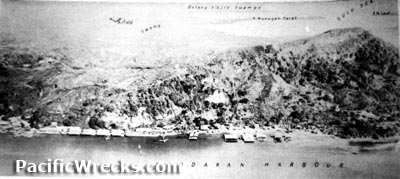 USAAF 1945 |
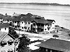
Location Lat 5° 49' 60N Long 118° 7' 0E Sandakan is located at an elevation of 3' above sea level on the northeast coast of Borneo. Borders Sandakan Harbor and Berhala Island (Berhala Rock). Also known as Sandakan Town. In the Sulu language Sandakan means "the place that was pawned". Also known as "Kampung Jerman" (village German) for the community of German immigrants that settled at this location. Also known as "Little Hong Kong" due to the presence of Chinese from Hong Kong. Also known as "Elopura" (Beautiful City) and later reverted back to Sandakan. Today located in Sabah State of Malaysia Borneo (East Malaysia) in Malaysia. Wartime History On January 19, 1942 the Imperial Japanese Army (IJA) occupied Sandakan. During the Japanese occupation, renamed "Elopura". During the Pacific War, developed into a large base area. Starting in late October 1944 attacked by Allied bombers and fighters. On July 1, 1945 assaulted by Australian Army 17th Division that liberated the area. American missions against Sandakan October 24, 1944–July 19, 1945 Sandakan Harbor Sandakan Harbor is located to the south of Sandakan at the entrance is Berhala Island (Berhala Rock). Sandakan Airfield Built by the Japanese using POW labor and still in use today Sandakan POW Camp During the Pacific War, thousands of Australian and British POWs were interned at Sandakan, before being marched across Borneo during the "Borneo Death Marches". References American Graves Registration Service (AGRS) Report of Activities 18 Oct. 1946 by 1st Lt. Irving R. Wendt Contribute
Information Last Updated
|
Map Fallingrain Photo Archive |
| Discussion Forum | Daily Updates | Reviews | Museums | Interviews & Oral Histories |
|