|
|
|
| Missing In Action (MIA) | Prisoners Of War (POW) | Unexploded Ordnance (UXO) |
| Chronology | Locations | Aircraft | Ships | Submit Info | How You Can Help | Donate |
|
 USAAF Dec 15, 1942  13th AF c1944  42nd BG c1944 |
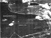
Location Lat 5° 15' 0S Long 154° 37' 60E Buka Island is roughly 50 kilometers long by 20 kilometers wide. On the western coast is Queen Carola Harbor. On the southern coast is Buka (Buka Town) and Buka Airfield. To the south borders Buka Passage and beyond Bonis on the north coast of Bougainville Island. Prewar and during the Pacific War, part of Kieta District in the Territory of New Guinea and considered part of the North Solomons, Northern Solomons. During 1975 became Bougainville Province in Papua New Guinea (PNG). On June 25, 2002 became part of the in Buka Rural LLG in Northern Bougainville District in Autonomous Region of Bougainville (AROB). Wartime History During 1941, a small Australian Army force was assigned to defend Buka (Town) and Buka Airfield. During January 1942 Japanese flyingboats scouted Buka and Buka Airfield. After the Japanese attack on Rabaul on January 21, 1942 the Australian garrison on Buka evacuated to Bougainville. On March 9, 1942, Japanese warships entered Queen Carola Harbor and soon afterwards occupied all of Buka Island. Starting in late August 1942 attacked by Allied aircraft until the middle of 1944. After the November 1, 1943 U.S. landing at Empress Augusta Bay, the Japanese initially believed it was a decoy and believed the real American objective was a landing against northern Bougainville and Buka and delayed launching a strong counter attack and instead attempted to reinforce Buka. Allied aircraft continued to bomb Buka until the middle of 1944. Although cut off from resupply the Japanese occupied Buka until the official surrender of Japan on September 2, 1945. Japanese and American missions against Buka January 3, 1942–June 15, 1944 Queen Carola Harbor Located on the western coast of central Buka Island. Occupied by the Japanese on March 9, 1942 and used as an anchorage. Buka (Buka Town) Located on the southern coast of Buka Island with Prewar Chinatown area and Buka Airfield. B-25H Mitchell 43-4??? Pilot Durkin MIA February 18, 1944 over northern Buka Contribute
Information Last Updated
|
Map 1943 |
| Discussion Forum | Daily Updates | Reviews | Museums | Interviews & Oral Histories |
|