|
|
|
| Missing In Action (MIA) | Prisoners Of War (POW) | Unexploded Ordnance (UXO) |
| Chronology | Locations | Aircraft | Ships | Submit Info | How You Can Help | Donate |
|
 10th AF March 1945 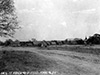 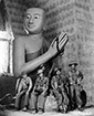 10th AF March 17, 1945 |
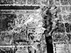
Location Lat 21° 58' 11N Long 96° 5' 15E Mandalay is located east bank of the Irrawaddy River the center of Burma (Myanmar). Prewar, a British built rail road lines that connects northward to Myitkyina and southward to Rangoon and continued to Pegu. To the south 445 miles away is Rangoon (Yangon). Prewar and during World War II part of British Burma. Today, Mandalay is the second-largest city in Burma, located in the Mandalay Region in the Republic of the Union of Myanmar (Myanmar). Wartime History At the start of the Pacific War, Mandalay was defended by the British but weakened without anti-aircraft guns and British aircraft withdrew to India. On April 3, 1942 Japanese Army Air Force (JAAF) bomb Mandalay starting a series of air raids that kill thousands of civilians and destroyed many homes and buildings. During May 1942 Mandalay was occupied by the Imperial Japanese Army (IJA). Starting in late 1942, attacked by Allied bombers and later fighters that neutralized the defenses and focused on bombing the city's railroad infrastructure. Allied missions against Mandalay November 20, 1942–July 26, 1944 During March 1945, Anglo-Indian forces, supported by the U. S Army Air Force (USAAF), 10th Air Force (10th AF) and Royal Air Force (RAF) aircraft. On March 21, 1945 the British Army, 14th Army, 33 Corps captured all of Mandalay as organized Japanese resistance ceased in the city. By April 1, 1945 the 36 Division begins following the railroad line southward towards Rangoon to drive the remaining Japanese forces out of Burma. Mandalay Palace (Fort Dufferin, Fort Mandalay) Built during 1857-1859 as the new royal capital built by King Mindon with an outer wall surrounded by a moat with a citadel at the center and was the residence of the last two kings of Burma: King Mindon and King Thibaw. On November 28, 1885 during the Third Anglo-Burmese War, British forces occupied the palace and captured the royal family. During the British colonial era, known as Fort Dufferin also known as simply Fort Mandalay. In May 1942 occupied by the Japanese and used as a supply depot. During 1944-1945 damaged by Allied aircraft bombing, including bombing the outer wall to create breeches. By March 17, 1945 liberated by the British Army. The only buildings that survived World War II was the royal mint and watch tower. In the 1990s a replica of the royal palace was built and is a major tourist destination owned by the Government of Myanmar. Mandalay Airfield (Mandalay Chanmyathazi Airport) Located to the south of Mandalay still in use today as Mandalay Seaplane Base Lat 21°59'0" Long 96°5'0" Mandalay Airport (Mandalay International Airport) Located 35km south of Mandalay built postwar completed 1999. Mytinge Bridge Built prewar as a road and rail road bridge spanning the Myitnge River (Nam Tu, Dokhtawaddy River) to the south of Mandalay. During early 1943, targeted by the U.S. Army Air Force (USAAF), 10th Air Force (10th AF) B-24 Liberators and B-25 Mitchells that damaged the bridge. Contribute
Information Last Updated
|
Map 1944-1945 Map Fallingrain Photo Archive |
| Discussion Forum | Daily Updates | Reviews | Museums | Interviews & Oral Histories |
|