|
|
|
| Missing In Action (MIA) | Prisoners Of War (POW) | Unexploded Ordnance (UXO) |
| Chronology | Locations | Aircraft | Ships | Submit Info | How You Can Help | Donate |
|
 USN March 10, 1942  90th BG August 9, 1943 |
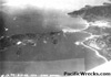
Location Lat 7° 3' 17" S Long 147° 2' 16" E Kela village is located at sea level on the north coast of New Guinea. Also spelled Keila. Some Allied wartime sources incorrectly spell this location Kila. Border Salamaua Harbor (Samoa Harbor) inside Huon Gulf. Inland to the southeast is a feature known as Kela Mountain (Keila Mountain). To the north is Kela Point (Keila Point). To the southeast is Salamaua and Logui and the mouth of the Francisco River. Prewar located in the Morobe District in Territory of New Guinea. Today located in Salamaua Rural LLG, Morobe Province in Papua New Guinea (PNG). Wartime History On March 8, 1942 occupied by the Imperial Japanese Army (IJA) "South Seas Detachment" 144th Infantry Regiment after landing at Salamaua. On September 11, 1943 liberated by the Australian Army, 5 Division, 42nd Infantry when they crossed the Francisco River to Salamaua Airfield and occupied the area. American missions against Kela Point (Keila Point) June 11, 1943–August 23, 1943 Contribute
Information Last Updated
|
Map 1942 Map 1943 Map Fallingrain Map Mapcarta |
| Discussion Forum | Daily Updates | Reviews | Museums | Interviews & Oral Histories |
|