|
|
|
| Missing In Action (MIA) | Prisoners Of War (POW) | Unexploded Ordnance (UXO) |
| Chronology | Locations | Aircraft | Ships | Submit Info | How You Can Help | Donate |
|
 USAAF January 5, 1943 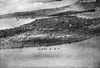 5th AF November 2, 1943 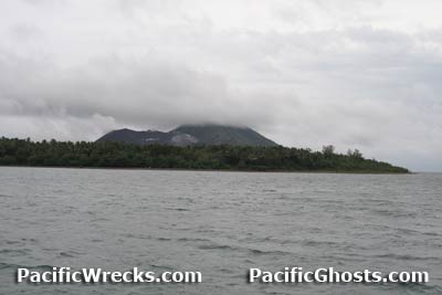 Justin Taylan 2007 |
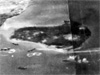
Location Lat 4° 15' 0S Long 152° 10' 60E Matupi Island is located to the south of Rabaul. Also spelled "Matupit". Borders Simpson Harbor to the west and Matupi Harbor to the east and Lakunai Airfield to the north. Between 1884–1914 part of Deutsch Neu Guinea (German New Guinea) until September 1914 at the start of World War I. Prewar and during the Pacific War part of the Territory of New Guinea. Today located in East New Britain Province in Papua New Guinea (PNG). Wartime History On January 23, 1942 occupied by the Japanese and developed into a supply area to support the adjacent Matupi Seaplane Base and Lakunai Airfield. Between May 1942 until January 1944 at least three separate executions of Allied personnel happened on Matupi Island with their remains buried in a mass grave on the island. Collectively, postwar they became known as the "Matupi Island Massacres". Occupied by the Japanese as developed into a base area to support adjacent Lakunai Airfield and Matupi Seaplane Base. At the northern tip of Matupi Island was a causeway bridge that connected the island to the southern tip of the Gazelle peninsula. During 1944, targeted by Allied bombers and fighters. Occupied by the Japanese for the duration of the Pacific War until the official surrender of Japan in September 1945. Allied mission against Matupi Island January 23, 1944–October 15, 1944 Today In the decades since the war, volcanic eruptions including the 1994 eruptions deposited substantial ash that has added landmass to Matupi Island and today is connecting it to the to the southern tip of the Gazelle peninsula and is no longer an island as it was during World War II. Matupi Seaplane Base Seaplane mooring area used by the Japanese during the war H6K5 Mavis Sunk in shallow water off Matupi Island A6M5 Model 52 Zero Manufacture Number 4323 Salvaged in 1971 from the water, destroyed in fire in San Diego B-25D "Fifi" 41-30311 Pilot Wilkins crashed November 2, 1943 Matupi Island Massacre / Matupi Mass Grave Between May 1942 until January 1944 at least three separate executions of Allied personnel happened on Matupi Island with their remains buried in a mass grave on the island. On May 26, 1942 Prisoner Of War (POW) Sgt David Stuart Brown was executed on Matupi Island and his body placed into a mass grave. On November 25, 1943 several POWs were taken from Keibitai Headquarters at Rabaul and executed on Matupi Island and their bodies buried in a mass grave. On January 14, 1944 a group of seventeen POWs were taken from Keibitai Headquarters at Rabaul and executed on Matupi Island and their bodies buried in a mass grave. One of those executed was RAAF F/O Ross B. O'Loghlen. Postwar Between May to June 1947 a RAAF Searcher Team led by S/L Keith Rundle investigated and exhumed a mass grave on Matupi and recovered remains. Between June to July 1950 the team returned and recovered more remains. In total, the remains of 30 aviators were recovered including 15 Australians. Some had been beheaded others had gunshot wounds. Matupi mass grave remains recovered and identified:
Today References Contribute
Information Last Updated
|
Map March 18, 1943 |
| Discussion Forum | Daily Updates | Reviews | Museums | Interviews & Oral Histories |
|