|
|
|
| Missing In Action (MIA) | Prisoners Of War (POW) | Unexploded Ordnance (UXO) |
| Chronology | Locations | Aircraft | Ships | Submit Info | How You Can Help | Donate |
|
 17th PRS January 5, 1943  USAAF Nov 18, 1943  Yoji Sakaida 2005 |
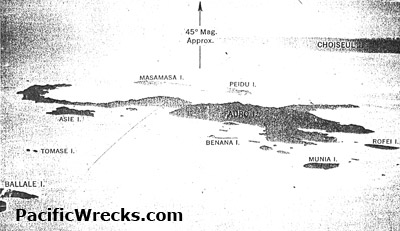
Location Fauro Island is the largest island in the Fauro Island Group (Fauro Islands) of Western Province in the Solomon Islands. Along the center spine of Fauro Island is Mount Pauboleala with an elevation of 574', Mount Lalauka with an elevation of 517' and Sharp Peak with an elevation of 484'. The northern arm of Fauro borders North Bay and includes Aroaro Point at the northern tip, Saulea Point and Patukovelai Point. The western shore borders Kavakava Bay. The eastern shore includes Javirabum Tara. Also on the eastern coast bordering Central Bay is Keketaia, Binasa, Natukova, Betisenda, Kariki. Eastward extends an arm known as East Cape terminating at Maero Point. To the east are Tauna Island, Masamasa Island and Piedu Island (Piru) and further east is Choiseul Island. To the west is Popotoa Island, Asie Island, Tomase Island, Baobi Island, Mabuu Island and Ruria Island. The western coast borders Kavakava Bay. Offshore to the west are Raumoaua Island, Mahanava Island, Uvuuuvunu Island, Maghotai Rock, Ghohuru Island, Benana Island, Munia Island. To the south is Rofei Island. Further to the west is the Shortland Island Group (Shortland Islands). To the northwest is Ovau Island and Nusave Island. To the northeast is Oema Island. Prewar Several coconut palms plantations harvesting copra were established on the coastline at several locations on Fauro Island. Wartime History During early 1942 occupied by the Japanese until the formal surrender of Japan on September 2, 1945. During November 1945 occupied by the Australian Army that established Kareki POW Camp (Japanese POW Camp) until repatriated in late January 1946. American missions against Fauro May 6, 1943–January 5, 1944 Kavakava Bay Borders the western side of Fauro Island Kareki Located on the eastern coast of Fauro borders Central Bay to the north. Postwar Japanese POW Camp. Toumoa Located on the southern coast of Fauro destroyed during the war by air attacks. Gareth Coleman adds: "A good friend of mine is local to the island and his village has the north land about 1/2 of the island. What is interesting to me is his village. They always watch where they put fires and can only have small ones due too buried ammunition. He continually digs up containers filled with brown liquid and other small indiscriminate items. he also has talked of a dump with several jeeps trucks and other items. there is talk of a hospital concrete bas with plenty of tables with items vials etc. The most interesting is the several aircraft in the harbours." P-40N Kittyhawk NZ3166 Pilot Hutton crashed November 16, 1943 six miles south of Fauro P-38H Lightning 42-66626 Pilot Eubanks MIA October 19, 1943 three miles NE of the East Cape, Fauro Island References Solomon Islands Government Topographic Map 1:50,000 "Fauro Island, Solomon Islands 0615609 X715 Edition 1-SI50K" information as of 2003, copyright 2007 Solomon Islands Government Topographic Map 1:50,000 "Oema Island, Solomon Islands 0615609 X715 Edition 1-SI50K" information as of 2003, copyright 2007 The Hard Slog (2012) by Karl James page 108, 155, 189, 256-257, 264, 297 (footnote 57), 313 (index) Contribute
Information Last Updated
|
| Discussion Forum | Daily Updates | Reviews | Museums | Interviews & Oral Histories |
|