|
|
|
|
| Missing In Action (MIA) | Prisoners Of War (POW) | Unexploded Ordnance (UXO) |
| Chronology | Locations | Aircraft | Ships | Submit Info | How You Can Help | Donate |
|
  5th AF September 1942 |
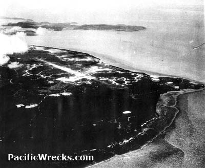
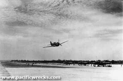
Location Lat 10° 35' 11S Long 142° 17' 24E Horn Island Airfield is located at the northern end of Horn Island (Ngurapai) in Queensland in Australia. Construction Built by the Australian Civil Constructional Corps and the Department of Main Roads as an advanced airfield. Construction began during 1940 and was completed by January 1942. Horn Island Airfield had two intersecting runways: an east-west runway measuring 5,000' x 150' and a southeast-northwest runway measuring 4250' x 150', both surfaced with bitumen and gravel. Wartime History During early 1942 attacked by Japanese bombers and fighters and defended by fighters. Later, Horn Island was an important stop on the ferry route from Australia northward to Port Moresby. Japanese missions against Horn Island March 14, 1942–June 18, 1943 Allied units based at Horn Island U.S. Army Air Force (USAAF) 49th FG, 7th FS (12 x P-40 detachment) Batchelor February 1942–April 18, 1942 Royal Australian Air Force (RAAF) No. 84 Squadron (Boomerang, P-40) Richmond April 43 - May 44 No. 32 Squadron (Hudson) March - September 1942 No. 7 Squadron (Beaufort) April - October 1944 Tadji Hudson Mark IIIa Serial Number A16-136 Destroyed on the ground March 14, 1942 B-17E "Tojo's Physic" 41-2640 Pilot O'Brien damaged July 30, 1942 during a collision on the ground, afterwards salvaged. By July 1945, the airfield was listed as an emergency airfield only. Today Still in use today as Horn Island Airport servicing the far north Queensland. Airport code: ICAO: YHID IATA: HID. Both runways remain in use: the first oriented 26/08 measuring 4,557' x 98' surfaced with asphalt and the second oriented 32/14 measuring 4,052' x 75' surfaced with asphalt at an elevation of 43' above sea level. References Airdromes Guide Southwest Pacific Area - 1 July 1945 Contribute
Information Last Updated
|
October 1943 July 1945 Map Fallingrain View in Google Earth |
| Discussion Forum | Daily Updates | Reviews | Museums | Interviews & Oral Histories |
|