|
|
|
|
| Missing In Action (MIA) | Prisoners Of War (POW) | Unexploded Ordnance (UXO) |
| Chronology | Locations | Aircraft | Ships | Submit Info | How You Can Help | Donate |
|
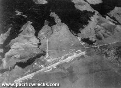 USAAF April 12, 1943  USAAF March 21, 1944  US Army c1944 |
Location Lat 2° 33' S Long 140° 29' E. Hollandia Airfield was located to the west of inland from Hollandia (Jayapura) on the north coast of western New Guinea. Also known as "Hollandia Airdrome", "Hollandia Drome" or "Hollandia Strip". Prewar and during the Pacific War, located in Dutch New Guinea (DNG) in the Netherlands East Indies (NEI). Between 1963-2007 part of Irian Jaya. Today located in the Jayapura Regency in Papua Province in Indonesia. To the north was the Depopre-Aerodrome track, today a sealed road known as Jalan Kertosari (Kertosari Highway) that connects to the Raya Airport Sentani (Sentani Airport Highway) and further to the north was the Cyclops Mountains. To the east is the Toatjidako River and further east is Sentani Airfield and Cyclops Airfield. and further east is Hollandia (Jayapura). To the south is Simboro Strait and to the southeast is Lake Sentani. To the west is the Delaoe River. Construction Built by the Japanese Army as a large airfield complex, with two runways, a western runway of 4,500' and a second southern runway spanning 6,200 x 340' (as of October 10, 1943). There were larger bomber revetments to the west of the strip, with (24) revetments and an additional (27) to the east of the field, connected by taxiways to the two runways, for a total of (51) anti-aircraft defenses included (4) light guns, later upgraded. A barracks area was located to the north of the strip, and road connected the strip to Hollandia town. In a later photo from March 21, 1944 the shorter runway is reported as being used as a parking and taxi area., and revetments around the north of the two strips and to the northeast. Japanese units based at Hollandia area airfields 7th Koku Kyoikutai 7th Sentai (Ki-49) mid-1943 33rd Sentai (Ki-43) 63rd Sentai (Ki-43) Dec 43 - Feb 1944 det Wewak & Hyane 77th Sentai (Ki-43) 248th Sentai (Ki-43) Ki-43-II Oscar Manufacture Number ? Captured and repaired by 80th FS, sent to USA American Expansion Captured by the US Army after the April 22, 1944 landings. The US Army further developed this airfield into two parallel runways: the longer 6,000' x 100' with a 500' overrun and 50' shoulders, surfaced with paced dirt, previously with marston matting. The shorter 5,500' x 100'. Both runways were oriented ESE to WNW. Extensive taxiways and over 100 aircraft ravetment areas to the north-east of the runways. During late April 1944 until the end of the Pacific War, designated as Army Post Office 565 (APO 565). American units based at Hollandia area airfields List of units at Hollandia Airfield and Sentani Airfield By July 1, 1945 disused and closed without a manned control tower and listed as a reserve military airfield. Today Disused since the Pacific War and overgrown. Contribute
Information Last Updated
|
Area Map July 1945 July 1945 View in Google Earth Photo Archive |
| Discussion Forum | Daily Updates | Reviews | Museums | Interviews & Oral Histories |
|