|
|
|
|
| Missing In Action (MIA) | Prisoners Of War (POW) | Unexploded Ordnance (UXO) |
| Chronology | Locations | Aircraft | Ships | Submit Info | How You Can Help | Donate |
|
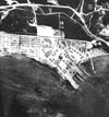 USN c1944 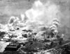 USN June 19, 1944 |
Location Tanapag Seaplane Base was located on Flores Point bordering Tanapag Harbor near Tanapag and Garapan on the west coast of Saipan Island in the Southern Islands Municipality of the Commonwealth of the Northern Mariana Islands (CNMI) in the United States of America (USA). Also known as Tanapag Harbor Seaplane Base. Construction During 1940, the Imperial Japanese Navy (IJN) built Tanapag Seaplane Base using technicians and supplies transported by Chitose, Kamoi and Kinugasa Maru. The facilities included a concrete seaplane ramp ands supporting facilities at the edge of Tanapag Harbor. Wartime History Used by the Japanese as a seaplane base with a concrete seaplane ramp area. Starting in 1944, attack by U.S. bombers and fighters until the American landing on Saipan on June 15, 1944. When captured, the wreckage of several Japanese flyingboats were captured on the seaplane ramp area. Afterwards, repaired and expanded by the U.S. for use as an emergency runway also known as Chalan Kanoa. H8K2 Emily Tail 006 Destroyed prior to American landing at Mutcho Point H8K2 Emily Sunk off into Tanapag Harbor at a depth of 25-30' off Tanapag Seaplane Base American units based at Tanapag VP-16 (PBM Mariner) June 1944 7th AF (HQ) Hawaii December 13, 1944 - ? During 1944–1945, U.S. Navy (USN) NATS (Naval Air Transport Service) based personnel at the airfield to handle cargo and passenger flights aboard seaplanes. Today The former seaplane base is part of Beach Road and no evidence remains. The emergency strip was incorporated into the local road network. Bruce Petty adds: "The beaches in this area where the Marines and Army landed in 1944 are now lined with hotels, restaurants, and shops, patronized mostly by Japanese tourists." Contribute
Information Last Updated
|
April 4, 1944 Map Fallingrain View in Google Earth Photo Archive |
| Discussion Forum | Daily Updates | Reviews | Museums | Interviews & Oral Histories |
|