|
|
|
|
| Missing In Action (MIA) | Prisoners Of War (POW) | Unexploded Ordnance (UXO) |
| Chronology | Locations | Aircraft | Ships | Submit Info | How You Can Help | Donate |
|
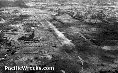 US Army c1944 |
Location San Pablo Airfield is located to the north of San Pablo on the eastern coast of Leyte in Leyte Province in the Eastern Visayas (Region VIII) of the Philippines. To the west is Bayug Airfield (Burouen, Burauen) and to the northwest is Buri Airfield. Construction Built by the Japanese as a single runway parallel to the road to the south. The runway was oriented roughly east to west with h taxiways on each side. Wartime History San Pablo Airfield was use by the Japanese until late October 1944 when the U.S. Army landed on eastern Leyte. During late October 1944 occupied by American forces and immediatly put back into service as a crash strip. Afterwards repaired with two parallel runways no. 1 and no. 2. On December 6, 1944 the Japanese launched Operation WA when Imperial Japanese Army (IJA) 3rd Parachute Regiment (Katori Shimpei Force) commanded by Lt Col Tsunehiro Shirai with two regiments made a combat paratrooper jump over San Pablo Airfield and Buri Airfield at roughly 6:00pm. Operation WA: Japanese Paratrooper Attack on Leyte December 6, 1944 American units based at San Pablo Although the
paratroopers caught the Americans by surprise, the first plane load of paratroopers
began leaving their aircraft direct over the Divisional Headquarters roughly 600' short
of their objective. Others were strung out well beyond the airstrip in an
area of tall trees, where many were entangled. One entire plane load jumped
to their deaths when the anchor line which pulls the rip chord failed to open.
Those who did reach the airfields were ineffective. The attack proved to be disorganized and an abortive
effort. Contribute
Information Last Updated
|
Map Dec 6, 1944 Map 1945 Map Fallingrain View in Google Earth |
| Discussion Forum | Daily Updates | Reviews | Museums | Interviews & Oral Histories |
|