Map of Japanese invasion of Tarakan Island
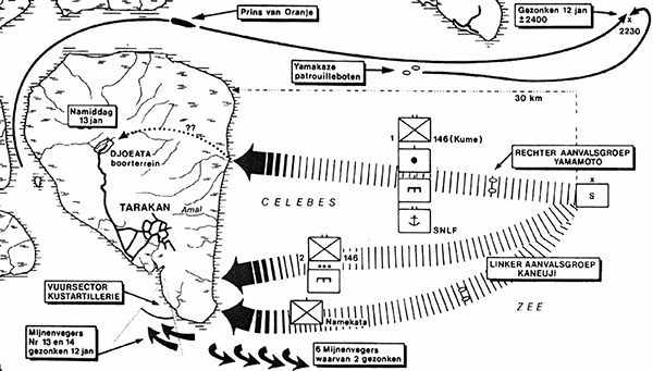
At the center left is Tarakan (Tarakan Town), Amal River and Djoeate boorterrein (Djoeate drilling site) and the Celebes Zee (Celebes Sea). The Japanese invasion that began on January 11, 1942 in the early morning hours the "Sakaguchi Detachment" under the command of Maj. Gen. Shizuo Sakaguch conducted an amphibious landing from the Celebes Sea on the east coast of Tarakan Island. The force included the "Right Wing Unit" under the command of Col. Kyōhei Yamamoto including 2nd Kure Special Naval Landing Force (2nd Kure SNLF) that landed to the north of the Amal River. The "Left Wing Unit" under the command Commander Col. Ken’ichi Kanauji plus supporting units landed at the southeast corner of Tarakan Island.
Credit: IJN Date: January 1942
Map
High Resolution Version
Acquire This Image |
Contribute
Information
Do you have photos or additional information?
Make A Donation | Previous Page | Pacific Wrecks |