|
|
|
| Missing In Action (MIA) | Prisoners Of War (POW) | Unexploded Ordnance (UXO) |
| Chronology | Locations | Aircraft | Ships | Submit Info | How You Can Help | Donate |
|
  New Zealand Army c1944 |
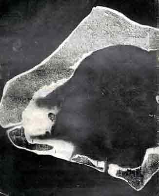
Location Lat 2° 13' 0S Long 146° 58' 60E Green Island Atoll includes Nissan Island (Green Island), Belil Island, Sirot Island, Barahun Island and Hon Islands in the center of Green Island Lagoon. To the northwest is Sau Island (Sale) and Pinipel Island. There are three passages from the surrounding Pacific Ocean into Green Island Lagoon. North Channel is located between Belil Island and Sirot Island. Middle Channel is located between Sirot Island and Barahun Island and Nissan Island (Green Island). Green Island Atoll is approximately 16km long by 8km wide, located approximately 60 nautical miles to the northwest of Buka Island. Also known as "Green Islands Atoll" or "Green Island Group". Today, part of Nissan Rural Local Level Government (Nissan Rural LLG), North Bougainville District, Autonomous Region of Bougainville (Bougainville Province), Papua New Guinea (PNG). Wartime History Occupied by the Japanese at the start of the Pacific War. Green Island Lagoon was used by the Japanese as a seaplane operating area in the early months of 1942 before Rabaul was captured. Between January 1942 to February 10, 1944 attacked by Allied bombers and fighters. Allied missions against Green Island January 1942–February 10, 1944 On January 30, 1944 raiding party of 300 soldiers, mostly from the New Zealand Army 30 Battalion landed on Nissan Island (Green Island). After reconnoitering for 24 hours, the group was withdrawn by sea having suffered five killed and ten wounded. On February 15, 1944 U.S. personnel plus the New Zealand Army 3rd New Zealand Division (less the 8th Brigade) made an amphibious landing on Nissan Island during "Operation Square Peg". Only about 500 Japanese base troops were stationed on Nissan, the rest had withdrawn to Feni Island. The remaining Japanese fought to the death with none surrendering or being taken prisoner. By February 23, 1944 organized Japanese resistance ceased but mopping up operations continued until the end of the month. Once secured, the native population was relocated to Guadalcanal for the remainder of the war. Immediately, U.S. Navy Construction Battalion "Seabees" began construction of Nissan Airfield on Nissan Island with two runways completed by the end of March 1944 and used for the rest of the year to attack Rabaul, New Britain and New Ireland. By July 1945, the last Allied personnel departed the Nissan Island (Green) for the Philippines. Afterwards, everything left on the island was destroyed or abandoned and the native population returned to the atoll. Green Island Atoll Green Island Atoll small atoll located to the northwest of Buka Island Green Island Lagoon located at the center of Green Island Atoll Nissan Island (Green) largest island in Green Island Atoll captured by Allies in 1944 and Nissan Airfield Belil Island located at the northern edge of Green Island Atoll Sirot Island located at the northwestern edge of Green Island Atoll Barahun Island located at the western edge of Green Island Atoll Hon Island (Torohan) located at the center of Green Island Lagoon Pinapei Island second largest island in Green Island Atoll located to the northwest of Green Island Atoll Sau Island (Sale) located to the northwest of Green Island Atoll Contribute
Information Last Updated
|
Map 1944 |
| Discussion Forum | Daily Updates | Reviews | Museums | Interviews & Oral Histories |
|