|
|
|
| Missing In Action (MIA) | Prisoners Of War (POW) | Unexploded Ordnance (UXO) |
| Chronology | Locations | Aircraft | Ships | Submit Info | How You Can Help | Donate |
|
 Ken Barber 1944 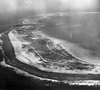 USN 1945  NASA 1990 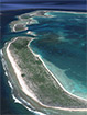 Google June 20, 2016 |
Location Lat 2° 49' 60S Long 171° 40' 60W Canton Island is the largest and most northern island in the Phoenix Island surrounded by the Pacific Ocean. Also spelled Kanton. Located about 1,500 mile to the southwest of Christmas Island. The atoll is a low, narrow rim of land enclosing a large shallow lagoon. Canton Island is 4.5 miles wide at the widest point from east to west and narrows at the southeast tip, which is nine miles to the furthest northwest point. Prewar and during World War II, part of the Gilbert Islands. Today located in the Republic of Kiribati. Prewar History Americans and British occupied the island in two separate camps. On March 3, 1938 President Roosevelt placed Canton and Enderbury under jurisdiction of the Department of the Interior. In April 1939, when Canton and Enderbury were placed under joint British and American control for fifty years, and "thereafter until such time as it may be modified or terminated by mutual consent". During 1938 and 1939 Pan American Airways laid developed the airfield and dredged the lagoon. Afterwards, Pan Am flying boats used Canton as a refueling stop for flights from Hawaii via the South Pacific to New Zealand. Wartime History Canton Airfield was an important refueling stop for aircraft being ferried from Hawaii via Palmyra to Canton, then via Fiji and Nouméa to Australia. The island was known for having only one palm tree and one runway. On November 1, 1943 Canton Island was bombarded by thirteen shells fired by Japanese submarine I-36. Charles Martin Quartermaster 3/c, USS Natchaug AOG-5 recalls: "I also remember that there was one tree on the island. We took a jeep, for a joy ride, If I remember it was getting dark and I hit this tree a glancing blow. That was my only claim to fame aboard my ship. Of all the 22 islands in the Pacific, I visited, this was one of the worst. No liberty just nothing to do. We would only spend a day or two to unload our gas and oil. Then head back to either Pearl Harbor or Guam." Erik Andal recalls: "My grandfather told me that the island had occasional Japanese fly over at night, but only once was there an attack from such planes. As I recall him saying, it was very brief and from one plane. No casualties. Without intent, my grandfather left me interested in the Central Pacific war topics." Today The airfield is still in use today. Arthur Hembree adds: "I was on Canton during the NASA operation Dominic and JTF ops in 1962. I have a few snapshots of interest, i.e. FFA plane N116 and other island facilities of the era. Photos are from box camera and may not transfer well." Thomas F. Equels adds: "While working for Contractor H&N on Canton Island in 1971, we saw the hull of the troop ship [USS President Taylor] and nearby on the beach was the fuselage of a PBY with a radial engine close by." Canton Airfield Wartime airfield still in use today USS President Taylor Ran aground February 14, 1942 and abandoned Contribute
Information Last Updated
|
Map Fallingrain Photo Archive |
| Discussion Forum | Daily Updates | Reviews | Museums | Interviews & Oral Histories |
|