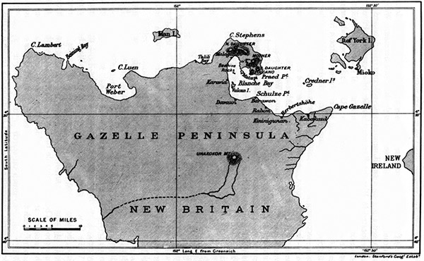
Map of the Gazelle Peninsula at the northern tip of East New Britain
Indicated on New Britain is Cape Lambert, Port Weber, Cape Luen, Man Island (Watom Island), Talili Bay, Cape Stephens (Tavui Point, Tavui No. 1), North Daughter (Tovanumbatir), Malaguna, Beehive Rocks (Dawapia Rocks), Karavia, Davaun, Vulcan Island (Vulcan), Blanche Bay, Matupi Island (Matupit), Mother, Volcano (Tavurvur), South Daughter (Turangunan), Praed Point, Schulze Point (Raluana Point), Barawon, Ralum, Kininigunan, Herbertshöhe (Kokopo), Kabakaul (Rapopo), Cape Gazelle and Mount Unakokor. To the east is the tip of New Ireland. To the northeast is Duke of York Islands and Mioko Island.
Credit: Australian Date: 1912
Map
High Resolution Version
Acquire This Image |
Contribute
Information
Do you have photos or additional information?
Make A Donation | Previous Page | Pacific Wrecks |