|
|
|
| Missing In Action (MIA) | Prisoners Of War (POW) | Unexploded Ordnance (UXO) |
| Chronology | Locations | Aircraft | Ships | Submit Info | How You Can Help | Donate |
|
 William Bartsch 1979  Peter via Carl Cox 2006 |
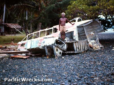
Location Panaeati Island is the largest island, densely forested in the Deboyne Island Group at the northern edge of Deboyne Lagoon. Also known as "Panniet Island". The island has a single conical peak with an elevation of 221m. A Wesleyan Mission is located on the western coast of the island. To the south is Panapompom Island and Nivani Island. Wartime History During May 6-10, 1942 the Japanese occupied the Deboyne area during the Battle of the Coral Sea. During late May or early June, the wreckage of G4M1 Betty 2271 Tail F-378 was moved or washed ashore onto the southern coast of Panaeati Island. References Milne Bay 1942 (1992) page 15 Contribute
Information Last Updated
|
Map 1970 |
| Discussion Forum | Daily Updates | Reviews | Museums | Interviews & Oral Histories |
|