Map of the first phase of the Naval Battle of Guadalcanal
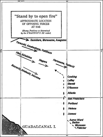
The map "Stand by to open fire" indicates the approximate location of opposing forces at 01:45 [November 13, 1942] at the start of the first phase. (Enemy positions as determined by the O'Bannon's SG radar).
The Imperial Japanese Navy (IJN) force at center is divided into smaller groups and was proceeding westward for a shore bombardment of Henderson FIeld on Guadalcanal. The Japanese warships (north to south):
(Left flank) Samidare, Murasame, Asagumo
Teruzuki, Amatsukaze, Yukikaze
Hiei flagship of Vice Admiral Abe, Kirishima, Nagara
Harusame, Yūdachi
(Right flank) Destroyers Ikazuchi,
Akatsuki and Inazuma
The U.S. Navy force at the lower right is in column formation with destroyers at the lead with cruisers at the center. The Americna column (north to south): USS Cushing (DD-376), USS Laffey (DD-459), USS Sterett (DD-407), USS O'Bannon (DD-450), USS Atlanta (CL-51), USS San Francisco (CA-38) flagship for Admiral Callaghan, USS Portland (CA-33), USS Helena (CL-50), USS Juneau (CL-52). Trailing behind in column to the southeast are USS Aaron Ward (DD-483), USS Barton (DD-599), USS Monssen (DD-436) and USS Fletcher (DD-445).
Credit: USN Date: November 13, 1942
Map
High Resolution Version
Acquire This Image |
Contribute
Information
Do you have photos or additional information?
Make A Donation | Previous Page | Pacific Wrecks |