|
|
|
| Missing In Action (MIA) | Prisoners Of War (POW) | Unexploded Ordnance (UXO) |
| Chronology | Locations | Aircraft | Ships | Submit Info | How You Can Help | Donate |
|
 Solomon Airlines 1990 |
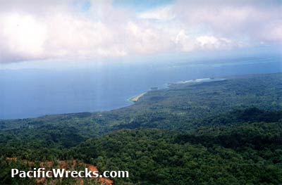
Location Lat 7° 45' 0S Long 156° 40' 0E Vella Lavella Island is located in the central Solomon Islands. Also spelled "Vella La Vella". Borders Vella Gulf to the east, and Wilson Strait to the south. To the west is Mbava Island (Baga Island) and Turovilu Island. To the southeast is Laipari Island. Prewar and during the Pacific War part of the British Solomon Islands Protectorate (BSIP). Today located in located in Western Province in the Solomon Islands. Wartime History Occupied by the Japanese. During October 1942, USS Grampus (SS-207) landed several coastwatchers on Vella Lavella to survey Barakoma as a potential site for an airfield. Starting in February 1943, attacked by American aircraft and the site of dog fights and aerial combat above the island. American and Japanese missions against Vella Lavella February 27, 1943–October 31, 1943 Land Battle of Vella Lavella (Vella Lavella Campaign) The Land Battle of Vella Lavella (also known as the Vella Lavella Campaign) was the American and New Zealand landing on Vella Lavella. On August 15, 1943 the U.S. Army 25th Infantry Division "Tropic Lighting", 35th Regimental Combat Team (RCT) landed with four U.S. Marine Corps (USMC) defense battalions. Later, reinforced by one battalion from the 145 Infantry Regiment. Immediately, the Barakoma area was developed into an Allied base area and began constructing Barakoma Airfield (Fighter Strip). The defending Japanese were driven to the northern end of the island, between Praso Bay and Mundi Mundi. On September 18, 1943 the Americans were relieved by the New Zealand Army 3rd Division, 37th Battalion and 35th Battalion that established their headquarters at Gill's Plantation, with the 30th Battalion held in reserve. The 35th and 37th Battalions made an amphibious flanking movement around the island, the 37th Battalion made an amphibious movement around the southern tip of the island and between Mbava (Baga) and Turovilu Island before landing at Mundi Mundi and Pakoi Bay. Meanwhile, the 35th Battalion made an amphibious movement around the east coast of Vella Lavella before landing at several points on the north coast including Paraso Bay, Doveli Cove, Varuasi and Warambari Bay. By early October 1943, roughly 600 Japanese had assembled at Horaniu on the northern tip of Vella Lavella. During the night of October 6, 1943 a Japanese destroyer force successfully evacuates them during the Naval Battle of Vella Lavella. Roughly 300 Japanese never reached the evacuation area and remained on the island. Some were killed in mopping up operations and the remainder fled into the interior of the island as holdouts. During August to October 1943, Japanese aircraft attempted bombing missions against the Allied forces on Vella Lavella but failed to inflict much damage. Japanese missions against Vella Lavella August 19, 1943-October 31, 1943 Afterwards, the island was an important American base for the remainder of the Solomons campaign until the war moved northwards. Due to its rapid capture, most of the island was spared excessive damage to its jungle and coconut palm plantations. Postwar In 1965, at least one Japanese holdout surrendered on Vella Lavella. Afterwards, the Japanese government via the Japanese embassy in the Solomon Islands attempted outreach efforts to locate any other surviving Japanese that might still be hiding on the island. This included dropping leaflets into the interior of the island, in hopes they would be found and reveal themselves. These efforts continued during the middle to late 1960s, without any other results. During 1989, a Japanese holdout was claimed to be sighted at Vorambare Bay, but this was never verified. David Cram adds: "I have a surrender notice leaflet that I found in the bush in Vella la Vella in 1995 that was dropped by the Japanese Embassy when they were looking for Japanese stragglers in the 1960s. I'll get a scan of that for you if you like. It was printed on water proof paper and as such was able to survive relatively intact." Barakoma Site of the American landing on August 15, 1943 Barakoma Airfield (Fighter Strip) Built by the Americans on the beach adjacent to Barakoma Geva Airfield Postwar built airfield Biloa Located on the southern tip of the island. Prewar, Biloa Mission was established at this location. Also known as Biloa Mission Station. Liapari Island Located opposite Biloa on the southeast corner of Vella Lavella. Remains of a U.S. Navy "Seabee" built road that connected Liapari to Ruruvai. A U.S. Navy (USN) PT Boat base was initially built at this location. Niarovai Located on the eastern coast between Ruravai to the north and Gill's Plantation to the south. War Memorial to NZ forces who landed in September 1943 located at this location. Maravari Located on the eastern coast of Vella Lavella Island to the south of the mouth of the Maravari River. Site of the New Zealand and United States Cemetery at Maravari. Gill's Plantation During 1943, American forces established their division headquarters and field hospital at this location. The only European building on the island was located here and used as a rest area for soldiers. Lambu Lambu Cove (Lambulambu) Located on the northeastern coast of the island, Kimbolia is located further to the north. PT Boat base was relocated here from Laipari which proved to be unsuitable. Japanese freighter sunk here in 12m, reportedly visibility is poor. Kimbolia Located on the northern coast of Vella Lavella Island. During late 1943, an American radar station was established at this location. Horoniu (Horaniu) Located on the northern coast of Vella Lavella Island. To the east is Kimbolia and Lambu Lambu Cove (Lambulambu). During the night of October 6, 1943 the remainder of the Japanese were evacuated during the Naval Battle of Vella Lavella. Vorambare Bay Location of the last battles between the Japanese and American forces during the recapture of the island. Japanese holdout sighting in 1989. P-40F Warhawk Piloted by Lewis MIA February 27, 1943 References Pacific Kiwis: Being The Story of the Service in the Pacific of the 30th Battalion, Third Division, Second New Zealand Expeditionary Force pages 66-98 Contribute
Information Last Updated
|
Map Sept 1943 |
| Discussion Forum | Daily Updates | Reviews | Museums | Interviews & Oral Histories |
|