|
|
|
|
| Missing In Action (MIA) | Prisoners Of War (POW) | Unexploded Ordnance (UXO) |
| Chronology | Locations | Aircraft | Ships | Submit Info | How You Can Help | Donate |
|
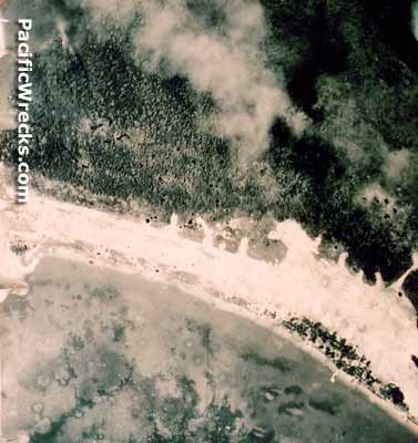 90th BG April 1944 |
Location Lat 0° 58' 0" S Long 131° 3' 0" E Samate Airfield was located located at an elevation of 46' / 14m at Samate (Semate) on the northeast tip of Salawati Island. Also spelled Semate. The Japanese also referred to this location as "Sorong Airfield" for nearby Sorong. This airfield was one of the most western Japanese airfields on New Guinea. Beyond to the east four miles away is Jefman Airfield (Efman). Prewar and during the Pacific War located in the Netherlands East Indies (NEI). Today located in Raja Ampat Regency in West Papua Province (West Irian Jaya) of Indonesia. Construction During 1942 occupied by the Japanese as they occupied western New Guinea. At this location, the Japanese built a single runway parallel to the coast surfaced with crushed coral. Wartime History Used by the Japanese as a forward airfield and part of the ferry route from Celebes to western New Guinea. Starting in the middle of June 1944 targeted by Allied bombers and fighters. During late May 1944, planes took off from Samate Airfield for strikes against the U.S. landing force and warships on Biak. American missions against Samate Airfield June 16, 1944–July 1945 Today Disused since the Pacific War. References Index to Air Bases - Research Report No. 85, I.G. No 9185 - July 30, 1944 AWM No. 15 Squadron Aitape-Wewak Campaign "[May 1945–July 1945] Bombing and strafing attacks were made on Sansapor." Contribute
Information Last Updated
|
Map Fallingrain Map Mapcarta Map 2007 |
| Discussion Forum | Daily Updates | Reviews | Museums | Interviews & Oral Histories |
|