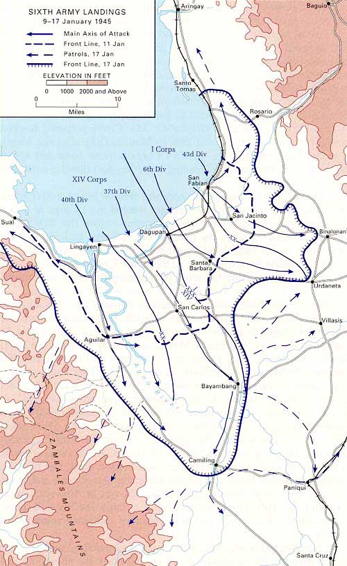
Map of Lingayen Gulf U.S. Army 6th Army Landings and advance inland
The solid line indicates the main axis of attack. On January 9, 1945 the U.S. Army 6th Army made an amphibious landing from Lingayen Gulf along three landing beach: Orange Beach (Lingayen) Blue Beach (Dagupan), White Beach (San Fabian). On January 11, 1945 the front line is indicated by the dotted line. On January 17, 1945 the dotted line with arrows indicates patrol routes as of that date. On January 17, 1945 the front line is indicated by hatches. Bordering Lingayen Gulf is Saul, Lingayen, Dagupan, San Fabian and Santo Tomas and Aringay. Further inland is Aguilar, San Carlos, Santa Barbara, San Jacinto, Rosario, Bayambang, Camiling, Binalonan, Urdaneta, Villasis, Paniqui and Santa Cruz. To the southwest are the Zambales Mountains. To the northeast is the Kennon Road to Baguio. The line with hatches indicates rail road lines. Double lines indicate roads. Also indicated is the mouth of the Agno River to the west of Lingayen. Today, this map encompasses locations in Region I (Ilocos Region) and Region III (Central Luzon) including Pangasinan
Province, La Union Province, Zambales
Province, Tarlac
Province and Benguet Province.
Credit: U.S. Army Date: January 9-17, 1945
Map
High Resolution Version
Acquire This Image |
Contribute
Information
Do you have photos or additional information?
Make A Donation | Previous Page | Pacific Wrecks |