|
|
|
| Missing In Action (MIA) | Prisoners Of War (POW) | Unexploded Ordnance (UXO) |
| Chronology | Locations | Aircraft | Ships | Submit Info | How You Can Help | Donate |
|
  Charles Page 2004 |
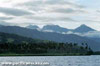
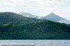
Location Lat 9° 22' 0S Long 150° 16' 0E Goodenough Island is part of the D'Entrecasteaux Islands off the north coast of New Guinea. Goodenough Island includes Vivigani bordering Boda Boda Bay on the northeastern coast and Bolubolu bordering Beli Beli Bay on the eastern coast. For its size, Goodenough ranks as the most mountainous island in the world. Borders the Solomon Sea to the north, Moresby Strait to the southeast and Ward Hunt Strait to the south and beyond the north coast of New Guinea. To the east is Fergusson Island. Prewar and during the Pacific War located in the Eastern District of the Territory of Papua. Today located in Milne Bay Province in Papua New Guinea (PNG). Wartime History On August 25, 1942 a group Japanese troops including 290 Imperial Japanese Army (IJA) and sixty No. 5 Sasebo Special Naval Landing Force (5th Sasebo SNLF) commanded by Cdr Tsukioka Torashige landed at Goodenough. Originally, these troops were bound for Taupota, where they would walk overland to Milne Bay but were caught on the Goodenough when their transportation barges were strafed by P-40E Kittyhawks, marooning them at Goodenough. On the September 23, 1942 three G4M1 Betty escorted by nine Zeros arrived to support the troops, the bombers dropping forty-four packages of rations by parachute. There was no news about an additional rescue attempt. However, the troops did learn that Port Moresby had not yet fallen to the Japanese Army. From this they could infer that rescue by a relief unit from Buna was also an unlikely prospect. American missions against Goodenough August 25, 1942–October 24, 1942 During on the night of October 22-23, 1942 the Australian Army 2/12 Battalion, 18th Brigade from Milne Bay landed from two destroyers on both sides of the island's southern tip. During the day of the 23rd intense fighting occurred. A Japanese prisoner was captured and rather than be forced to talk, bit his tongue off! That night, 250 Japanese were evacuated by submarine to Fergusson Island, and from there taken by cruiser to Rabaul. The remaining defenders were mopped up and island declared secured by the October 24, 1942. During the remainder of 1942, eastern coast of Goodenough Island was developed by the Allies with staging bases at Bolubolu and Vivigani plus Vivigani Airfield used as a forward airfield for operations against the Japanese. On October 21, 1943 the U.S. Army 6th Army "Alamo Force" Headquarters arrives from Milne Bay. Goodenough was used by the Allies until the end of the Pacific War. Today In the early 1970s, an Australian missionary reported seeing a Japanese holdout on Goodenough. The only link to Goodenough by charter aircraft from Milne Bay or a weekly ferry service aboard Atolls Queen. References The Rest of the Story by Richard Dunn Milne Bay 1942 (1992) pages 114 (map), 115 (Japanese landing August 25, 1942), 116 (map) Contribute
Information Last Updated
|
Map 1943 Map 1944 Photo Archive |
| Discussion Forum | Daily Updates | Reviews | Museums | Interviews & Oral Histories |
|