Missing In Action (MIA)
Prisoners Of War (POW)
Unexploded Ordnance (UXO)
Chronology
Locations
Aircraft
Ships
Submit Info
How You Can Help
Donate
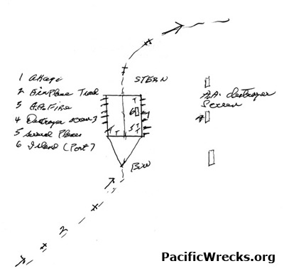
Map depicting the flight path of
B-26 "Susie-Q" 40-1391
piloted by James P. Muri across the flight deck of
Akagi
1.
Akagi
2. Our plane trail [Flightpath of
B-26 "Susie-Q" 40-1391
]
3. A. A. fire
4. Destroyer screen
5. Several planes
6. Island (port) [
Midway Atoll
,
Eastern Island
and
Midway Airfield
]
Credit:
James P. Muri
Date:
June 4, 1942
Map
High Resolution Version
Acquire This Image
|
Contribute Information
Do you have photos or additional information?
Previous Page
Discussion Forum
Daily Updates
Reviews
Museums
Interviews & Oral Histories
Pacific Wrecks Inc.
All rights reserved.