Missing In Action (MIA)
Prisoners Of War (POW)
Unexploded Ordnance (UXO)
Chronology
Locations
Aircraft
Ships
Submit Info
How You Can Help
Donate
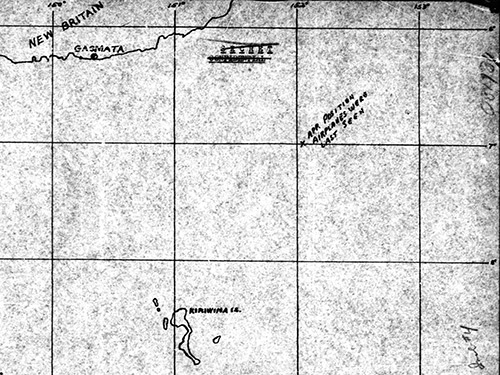
Map depicting the loss of
P-38G 42-12698
,
P-38G 42-12856
and
P-38H "Charlcie Jeann" 42-66516
Missing In Action (MIA) over the
Solomon Sea
At the top of the map is the southern coast of
West New Britain
and
Gasmata
. The "X" indicates the "apr position airplanes were last seen" at the bottom is
Kiriwina Island
.
Credit: MACR 1116 page 8 / MACR 1104 page 3 Date:
October 13, 1943
Map
High Resolution Version
Acquire This Image
|
Contribute Information
Do you have photos or additional information?
Previous Page
Discussion Forum
Daily Updates
Reviews
Museums
Interviews & Oral Histories
Pacific Wrecks Inc.
All rights reserved.