Pacific Wrecks
Pacific Wrecks    
  Missing In Action (MIA) Prisoners Of War (POW) Unexploded Ordnance (UXO)  
Chronology Locations Aircraft Ships Submit Info How You Can Help Donate

PacificWrecks.com
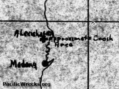
Map of approximate crash site of P-38H 42-66546 and P-38H 42-66834
The two aircraft suffered an aerial collision over the target area. The map is annotated with "+ Approximate crash area" also indicated is Alexishafen and Madang and a black line indicating the north coast of New Guinea.
Credit: MACR 1260 page 4  Date: November 9, 1943
Map   Enlargement

High Resolution Version
Acquire This Image
|
 

Contribute Information
Do you have photos or additional information?

Make A Donation | Previous Page | Pacific Wrecks

  Discussion Forum Daily Updates Reviews Museums Interviews & Oral Histories  
 
Pacific Wrecks Inc. All rights reserved.
Donate Now Facebook Twitter YouTube Instagram