|
|
|
|
| Missing In Action (MIA) | Prisoners Of War (POW) | Unexploded Ordnance (UXO) |
| Chronology | Locations | Aircraft | Ships | Submit Info | How You Can Help | Donate |
|
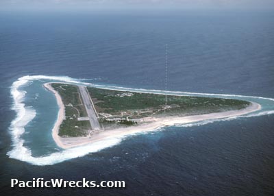 USCG 1987 |
Location Lat 24° 17' 23N Long 153° 58' 45E Marcus Airfield is located at an elevation of 22' above sea level spanning the length of Marcus Island (Minamitorishima). Also known as Marcus Island Airfield, Minamitorishima Airfield, Minami Torishima Airfield or Minami Tori Shima Airfield. Today, Marcus Airfield is administratively part of Ogasawara Subprefecture of Japan. Construction Built by the Japanese Navy during 1935. The airfield included intersecting runways that spanned the length of the island: Runway No. 1 and Runway No. 2. Wartime History As of September 1, 1943 revetments and at least one hangar were present at the base, along with fuel storage and radio masts and RDF station. The airfield was defended by light and heavy anti-aircraft guns emplaced on the island. Between March 1942 until July 1945 Marcus was attacked by U.S. carrier aircraft and later land based bombers and bypassed, leaving the garrison isolated and cut off from resupply, aside from submarine or rescue. American missions against Marcus March 4, 1942–July 4, 1945 On August 31, 1945 the surviving garrison of Marcus under the command of Rear Admiral M. Matsubara officially surrendered aboard USS Bagley DD-386 to Rear Admiral F. E. M. Whiting. to U.S. Army General Whiting. Marcus Airfield was occupied by American forces and the airfield was repaired and improved. Postwar During 1951-1968 the U.S. Coast Guard (USCG) improved the airfield and installed a tall navigation mast at roughly the center of the former Runway No. 1 during the 1951-1968 era. This mast was one of the tallest structures in the Pacific until 1985. Today During 1968, Marcus Island and Marcus Airfield were returned to Japan and is administratively part of Ogasawara Subprefecture. Still in use today as Minami Torishima Airport classified as a small airport used by the Japan Self Defense Force (JSDF). Airport codes: ICAO: RJAM IATA: MUS. Today, only the no. 2 runway remains in use that is oriented 23/05 measures 4,500' x 145' surfaced with asphalt. Contribute
Information Last Updated
|
Map Sept 1, 1943 Map Fallingrain View in Google Earth |
| Discussion Forum | Daily Updates | Reviews | Museums | Interviews & Oral Histories |
|