Pacific Wrecks
Pacific Wrecks    
  Missing In Action (MIA) Prisoners Of War (POW) Unexploded Ordnance (UXO)  
Chronology Locations Aircraft Ships Submit Info How You Can Help Donate

PacificWrecks.com
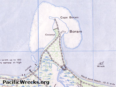
Topographic map of Boram (Cape Boram) on the north coast of New Guinea
Indicated is Boram and Cape Boram surrounded by a fringing coral reef with jetties on the western base of the peninsula. To the east is Boram Bay and to the west is Wewak Harbor. Beyond to the north is the Bismarck Sea. "Wreck" is the shipwreck of a "Borneo Maru Class vessel" sunk to the east of Cape Boram, likely the Nagato Maru sunk September 2, 1943.
Credit: U.S. Army  Date: July 1944
Map   Enlargement

High Resolution Version
Acquire This Image
|
 

Contribute Information
Do you have photos or additional information?

Previous Page

  Discussion Forum Daily Updates Reviews Museums Interviews & Oral Histories  
 
Pacific Wrecks Inc. All rights reserved.
Donate Now Facebook Twitter YouTube Instagram