|
|
|
|
| Missing In Action (MIA) | Prisoners Of War (POW) | Unexploded Ordnance (UXO) |
| Chronology | Locations | Aircraft | Ships | Submit Info | How You Can Help | Donate |
|
 17th PRS September 11, 1944  RNZAF 1945 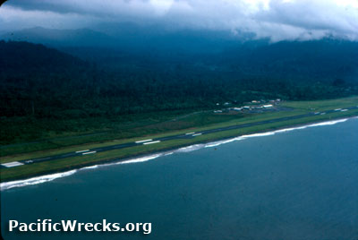  David Paulley 1982 |
Location Lat 6° 18' 19S Long 155° 43' 41E Kieta Airfield is located south of Kieta and the Aropa River, parallel the eastern coast of Bougainville. Also known as "Aropa Airport". Prewar and during the Pacific War part of the Territory of New Guinea and considered part of the North Solomons, Northern Solomons. Today part of the Autonomous Region of Bougainville (Bougainville Province) in Papua New Guinea (PNG). Construction Built prewar as a single runway that measured 2,624' x 262' (800m x 80m) surfaced with grass. Wartime History On March 31, 1942 occupied by the Japanese without resistance. On June 19, 1942 a reconnaissance was made of the runway. On July 8, 1942 staff officers from the 25th Air Flotilla and the 8th Base Force and the commander of the 14th Establishment Unit over flew Kieta Airfield in a flying boat to survey it for potential military use. As a result of this reconnaissance, the commander of the 25th Air Flotilla sent a report outlining his conclusions to the Airbase Force Command. They deemed expansion of the airfield would not be completed until early September 1942, after the new airfield under construction at Lunga Point Airfield [Henderson Field] was scheduled to be finished, making the immediate need to expand this location negligible. Further, the runway was not able to be expanded because of the terrain, suffered drainage problems and had obstructions at on one end. Although neglected by the Japanese as a landing ground, Kieta Airfield was bombed by the Allies during 1943 until the middle of June 1944. A 1945 Australian Army Survey Map listed Kieta Airfield as "destroyed". Allied missions against Kieta January 21, 1943–June 14, 1944 Postwar After the Pacific War, Kieta Airfield was repaired and used as the main airport serving Bougainville. Known as "Kieta Airport" or "Aropa Airport". Airport Codes: ICAO: AYKT, IATA: KIE. Bougainville Crisis During the "Bougainville Crisis", this airfield was abandoned in 1988 and much of the airport infrastructure was destroyed. In 1999 used by the Peace Monitoring Group (PMG). After the crisis, the airport was again abandoned and overgrown. Today During February 2012 the owners announced their intention to reopen the airport. On December 12, 2014 Aropa Airport was reopened during a ceremony attended by Prime Minister of Papua New Guinea Peter O'Neill and President of the Autonomous Region of Bougainville John Momis. The rebuilt aircraft is capable of accommodating Bombardier Dash 8 aircraft. Air service is provided by Air Niugini, PNG Air and charter aircraft. References Japanese army operations in the South Pacific area: New Britain and Papua campaigns, 1942–43 pages 124-125 National Airport Corporation (NAC) - Aropa Contribute
Information Last Updated
|
Map 1945 Map Fallingrain View on Google Earth Photo Archive |
| Discussion Forum | Daily Updates | Reviews | Museums | Interviews & Oral Histories |
|