Pacific Wrecks
Pacific Wrecks    
  Missing In Action (MIA) Prisoners Of War (POW) Unexploded Ordnance (UXO)  
Chronology Locations Aircraft Ships Submit Info How You Can Help Donate

PacificWrecks.com
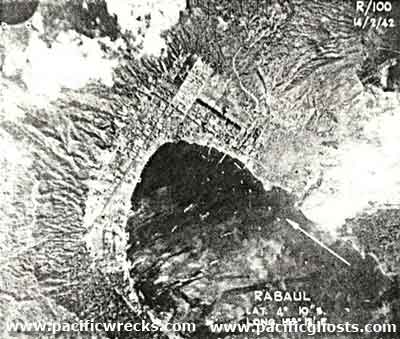
Vertical view of Rabaul and in Simpson Harborfull of Japanese ships
The arrow indicates north. The annotation at the lower center reads "Rabaul Lat 4°  10" S Long Long 152° 10'E". This reconnaissance photograph was used to plan the first U.S. bombing mission by B-17 Flying Fortresses that took off on February 22, 1942 from Garbutt Field at Townsville flying overnight to arrive on February 23, 1942 at dawn to bomb Japanese shipping in Simpson Harbor off Rabaul.
Credit: RAAF  Date: February 14, 1942
B&W  

High Resolution Version
Acquire This Image
|
 

Contribute Information
Do you have photos or additional information?

Previous Page

  Discussion Forum Daily Updates Reviews Museums Interviews & Oral Histories  
 
Pacific Wrecks Inc. All rights reserved.
Donate Now Facebook Twitter YouTube Instagram