 |
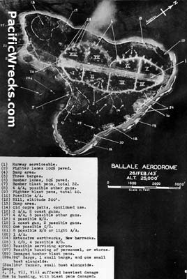
Vertical view from 25,000' of Ballale Airfield on Ballale Island with photographic interpretation
The revetment loop areas are annotated on the southeastern side: I, II, III and IV on the western side: V, VI, VII and VIII on the northwestern side.
(1) Runway serviceable.
(2) Fighter lanes 100% paved [taxiways]
(4) Dump area.
(5) Three barges.
(6) Bomber lanes 80% paved [taxiways]
(7) Bomber blast pens, total 32. [revetments northwestern side]
(8) 4 A/A, possible other guns.
(9) Fighter blast pens, total 40. [revetments southeastern side]
(10) Possible A/A.
(12) Fill, altitude 300'.
(13) Dump area.
(14) Old copra paths, continued used. [pathways from copra plantation].
(16) 3 A/A, 2 coast guns.
(17) 4 A/A, 5 possible other guns.
(18) 4 possible M/G.
(19) 1 coast gun, 2 possible guns.
(20) One possible C/G.
(21) 6 possible M/G or light A/A.
(22) 1 A/A
(24) Extensive earthworks, new barracks.
(25) 1 C/G, 4 possible M/G
(26) Possible service apron.
(27) Possible housing of personnel, or stores.
(29) Damaged bomber blast pens.
(29a) 90' barge, 1 small barge, and one small boat alongside.
(30a) 180' tanker, small boat alongside.
I, II, VII, VIII suffered heaviest damage due to bombing, with blast pens damaged.
Credit: USAAF, Terrain Study No. 41 Date: February 26, 1943
B&W
High Resolution Version
Acquire This Image |
Contribute Information
Do you have photos or additional information?
Previous Page
|
|