Pacific Wrecks
Pacific Wrecks    
  Missing In Action (MIA) Prisoners Of War (POW) Unexploded Ordnance (UXO)  
Chronology Locations Aircraft Ships Submit Info How You Can Help Donate

PacificWrecks.com
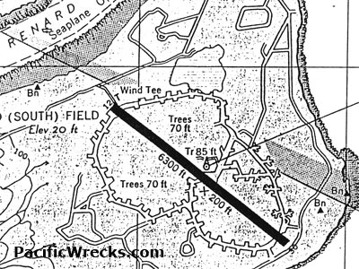
Approach map for Renard Field (South Field) on Banika Island in the Russell Islands Group
The runway is oriented 12/30 measures 6,300' x 200' with taxiway loops and revetments on both sides and roads. Tower Renard. To the north and east is Renard Sound used as a Seaplane Operating Area.
Credit: USN  Date: January 1945
Map   Enlargement

High Resolution Version
Acquire This Image
|
   

Contribute Information
Do you have photos or additional information?

Previous Page

  Discussion Forum Daily Updates Reviews Museums Interviews & Oral Histories  
 
Pacific Wrecks Inc. All rights reserved.
Donate Now Facebook Twitter YouTube Instagram