|
|
|
|
| Missing In Action (MIA) | Prisoners Of War (POW) | Unexploded Ordnance (UXO) |
| Chronology | Locations | Aircraft | Ships | Submit Info | How You Can Help | Donate |
|
 Territory of Hawaii June 21, 1940 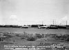 Territory of Hawaii July 31, 1948 |
Location Lat 21° 9' 10N Long 157° 5' 47W Molokai Airfield is located near Hoolehua on Molokai (Molokaʻi) in Hawaii in the United States of America. Also known as Hoolehua Airport. Borders Keonelele Avenue to the north and Mahana Road to the south. Prewar known as "Homestead Field". Construction Built prewar, known as Homestead Field. By May 1944, the airfield had two intersecting runways. Wartime History During World War II, used by the U.S. Navy (USN), U.S. Marine Corps (USMC) and U.S. Army Air Force (USAAF). American units based at Molokai 30th BG, 38th BS (B-24) US arrives October 20, 1943 Today Still in use today as Molokai Airport (also known as Hoolehua Airport). The airport has has two runways. The first is oriented 23/05 measures 4,494' x 100' surfaced with asphalt. The second runway is oriented 35/17 measures 3,118' x 100' surfaced with asphalt. Airport Codes: FAA: MKK ICAO: PHMK IATA: MKK. Serviced by Mokulele Airlines and Empire Airlines. References Hawaii Aviation - Molokai Airport (Hoolehua Airport) Holokai Airport Official Website CAA Region IX 1947 National Airport Plan, Proposed improvements February 26, 1947 Contribute
Information Last Updated
|
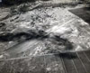
Map 1944 Map Fallingrain Photo Archive |
| Discussion Forum | Daily Updates | Reviews | Museums | Interviews & Oral Histories |
|