 |
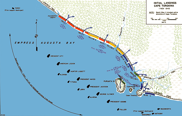
Map of Initial Landings Cape Torokina on western Bougainville
The map includes Empress Augusta Bay with Puruata Island and Torokina Island off western Bougainville with Koromokina Lagoon, Koromokina River, Empress Trail and Buretoni Mission Trail. At the center are two lines of U.S. transports USS Crescent City (APA-21), USS American Legion (APA-17), USS President Jackson (APA-18), USS George Clymer (APA-27). At the lower right are three fire-support destroyers: USS Sigourney (DD-643), USS Anthony (DD-515) and USS Wadsworth (DD-516). Beyond screening destroyers USS Conway (DD-507), USS Cony (DD-508), USS Eaton (DD-510) and USS Renshaw (DD-499). The U.S. Marine landing beaches are indicated including Red 1, Red 2, Red 3, Yellow 1, Yellow 2, Yellow 3, Blue 1 (Cape Torokina), Blue 2, Blue 3, Green 1 (Puruata Island) and Green 2.
Credit: USMC Date: November 1, 1943
Map
High Resolution Version
Acquire This Image |
Contribute Information
Do you have photos or additional information?
Previous Page
|
|