|
|
|
|
| Missing In Action (MIA) | Prisoners Of War (POW) | Unexploded Ordnance (UXO) |
| Chronology | Locations | Aircraft | Ships | Submit Info | How You Can Help | Donate |
|
 Shirley Cook 1975  Josh McDade 1999 |
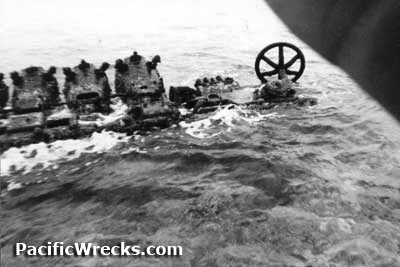
Location Kieta Harbor is formed by the Kieta Peninsula to the west, Kieta Bay and beyond Kieta on the mainland of eastern Bougainville to the south and Bakawari Island to the east. To the northwest borders Mawara Bay. Prewar and during the Pacific War part of Kieta District in the Territory of New Guinea and considered part of the North Solomons (Northern Solomons). During 1975 became Bougainville Province in Papua New Guinea (PNG). On June 25, 2002 became part of the in Arawa Rural LLG in Central Bougainville District in Autonomous Region of Bougainville (AROB). Wartime History On March 31, 1942 at dawn, Kieta was occupied without resistance by a platoon of Japanese Navy Special Naval Landing Forces (SNLF). During the Pacific War used as a Japanese anchorage. Starting in late January 1943 targeted by Allied planes until the end of the Pacific War. Occupied by the Japanese until the official surrender of Japan in September 1945. Allied missions against Kieta Harbor January 21, 1943–June 14, 1944 Kieta Wharf The Kieta Wharf extends into Kieta Bay. Beside the wharf is a half submerged wreck. During 1999, the Christian book ship MV Doulos was docked for a month at Kieta Wharf. Daihatsu Landing Craft Wogoromodo Reef Sunk atop Wogoromodo Reef between Tautsina Island and Arovo Island. Contribute
Information Last Updated
|
Map 1975 |
| Discussion Forum | Daily Updates | Reviews | Museums | Interviews & Oral Histories |
|