|
|
|
|
| Missing In Action (MIA) | Prisoners Of War (POW) | Unexploded Ordnance (UXO) |
| Chronology | Locations | Aircraft | Ships | Submit Info | How You Can Help | Donate |
|
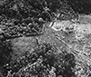 RAAF April 1945 |
Location Lat 6° 41' 20S Long 155° 26' 30E Monoitu is located near the Hani River at an elevation of 830' in southern Bougainville Island. Allied wartime spelling Monoitu. Also spelled Monitu. Connected by the Monoitu-Kahili Trail to Kahili. Prewar and during the Pacific War located in the Kieta District in the Territory of New Guinea. Today located in the Autonomous Region of Bougainville in Papua New Guinea (PNG). Prewar The Catholic church established Monoitu Mission (Monitu Mission) at this location prewar. Wartime History During early 1942, Monoitu was occupied by the Imperial Japanese Army (IJA). Bombed by Allied aircraft during late 1943 until the middle of 1944. Allied missions against Monoitu (Monitu) November 21, 1943–June 14, 1944 By early 1945, Japanese soldiers in the Monoitu area planted gardens and tended to crops to provide subsistence for themselves. During the middle of 1945 the Japanese Army, 4th Heavy Artillery Regiment headquarters was based at Monoitu. On June 10, 1945 assaulted by the Australian Army 24 Infantry Battalion. P-39Q Airacobra Serial Number 42-19587 Pilot Barrington MIA March 5, 1944 SBD-5 Dauntless Bureau Number 35961 Pilot Frost MIA December 18, 1943 Postwar In 1947 a kiap station (patrol station) was established at Monoitu manned by three kiaps (patrol officers) Messrs Henderson, Harvey, McDonald, Farlow and McAuley. References NAA [Papua and New Guinea] Photograph of Monoitu house kiap, showing Messrs Henderson, Harvey, McDonald, Farlow and McAuley - 1947 - New Guinea, Bougainville, Monoitu (NAA: A6510, 1961) Contribute
Information Last Updated
|
Map Fallingrain Map Mapcarta |
| Discussion Forum | Daily Updates | Reviews | Museums | Interviews & Oral Histories |
|