|
|
|
|
| Missing In Action (MIA) | Prisoners Of War (POW) | Unexploded Ordnance (UXO) |
| Chronology | Locations | Aircraft | Ships | Submit Info | How You Can Help | Donate |
|
 13th AF c1943 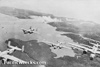 42nd BG c1943  USAAF November 18, 1943  David Paulley 1982 |
Location Tonolei Harbor borders the southern coast of Bougainville. Wartime spelling includes "Tonolai", "Tonalei" or "Tonelei". To the east is East Point at the southeastern tip of Bougainville. To the west is Pupukuna Point bordering Moisurui Bay. To the south is Sand Island and Tuarato Island. Prewar and during the Pacific War located in the Territory of New Guinea and was considered part of the North Solomons or Northern Solomons. During 1975 became Bougainville Province in Papua New Guinea (PNG). On June 25, 2002 became the Autonomous Region of Bougainville (AROB). Today located in South Bougainville District. Wartime History During early 1942, occupied by the Japanese. Tonolei Harbor was used by Japanese warships and transports as an anchorage and supply area and was part of the Buin Anchorage. Between October 1942 until June 1944 this location was targeted by Allied bombers and fighters. Occupied by the Japanese until September 1945. American missions against Tonolei Harbor October 13, 1942–June 4, 1944 Houn Maru Ran aground May 19, 1943 Contribute
Information Last Updated
|
| Discussion Forum | Daily Updates | Reviews | Museums | Interviews & Oral Histories |
|