 |
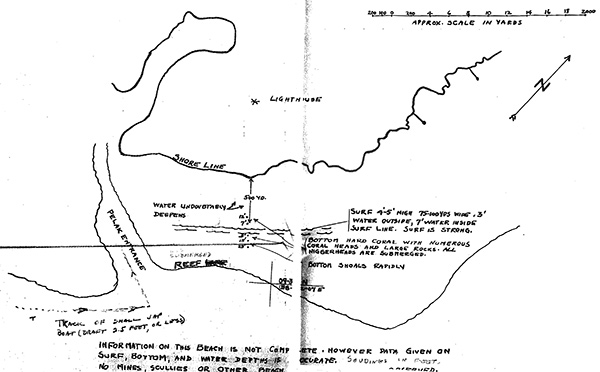
Sketch map of southern Gagil-Tamil Island created by photographic and special reconnaissance of Yap
The black line indicates the southern coast of Gagil-Tamil Island with the Japanese Lighthouse at Dalaap (Dalaap). The thiner line is the reef line and Pelak Entrance. Also indicated is the track of small Jap boat (dragt 2.5 feet or less). The note at the bottom of the map reads: "Information on this beach is not complete however data given on surft, bottom and water depth is accurate. Soundings in feet." Off the shoreline 500 yards is the note: "Surf 4'-5' high 75-100 yds wide .3' water outside, 7' water inside surf line. Surf is strong." This map was created by observations by USS Burrfish (SS-312) and a team of five frogmen from Underwater Demolition Team that surveyed the reef.
Credit: USN via Photographic and Special Reconnaissance of YAP - PALAU Islands Date: August 24, 1944
Map
High Resolution Version
Acquire This Image |
Contribute Information
Do you have photos or additional information?
Previous Page
|
|