|
|
|
|
| Missing In Action (MIA) | Prisoners Of War (POW) | Unexploded Ordnance (UXO) |
| Chronology | Locations | Aircraft | Ships | Submit Info | How You Can Help | Donate |
|
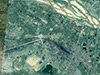 Google Earth 2006 |
Location Lat 23° 43' 40N Long 87° 16' 15E Pandaveswar is located at an elevation of 206' / 62m above sea level in the Paschim Bardhaman District of West Bengal State in eastern India. Also spelled "Pāndaveswar". To the north is the East India Rail Road and Ajay River. Pandaveswar Airfield Wartime airfield, disused since the war Contribute
Information Last Updated
|
Map Fallingrain |
| Discussion Forum | Daily Updates | Reviews | Museums | Interviews & Oral Histories |
|