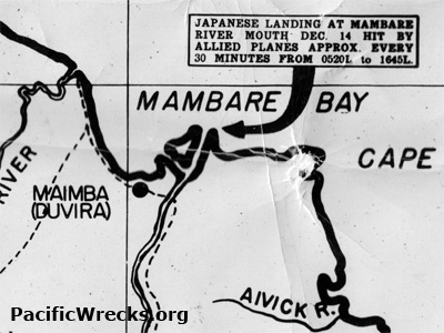
Map of Mambare River and Mambare Bay on the north coast of New Guinea The upper annotation reads: "Japanese landing at Mambare River mouth Dec. 14 [1942] hit by Allied planes approx. every 30 minutes from 0530L to 1645L." To the east is Cape Ward Hunt, to the south is Maimba (Duvira) and the Mambare River and to the west is the Gira River. Credit: U.S. Army Date: 1943
Map Enlargement