|
|
|
|
| Missing In Action (MIA) | Prisoners Of War (POW) | Unexploded Ordnance (UXO) |
| Chronology | Locations | Aircraft | Ships | Submit Info | How You Can Help | Donate |
|
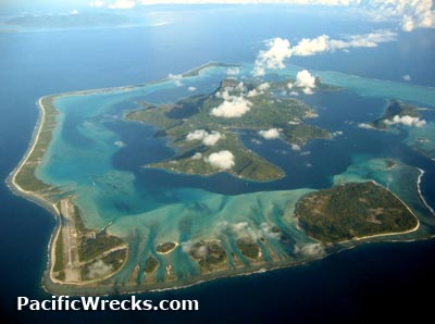 c1990 |
Location Lat 16° 29' 58" S Long 151° 44' 14" W Bora Bora Island is part of Bora Bora Atoll in the leeward group in the Society Islands (Society Island Group). Also spelled Pora Pora. At the center of the island are the peaks of Pic Mataihua and Otemanu. To the north is Motu Mute Island. Beyond to the southwest is Taha'a and Raiatea. Today located in French Polynesia. Wartime History On January 22, 1942 survey vessel USS Sumner (AG-32) arrives at Bora Bora and commences survey work. On February 17, 1942 American forces begin arriving including U.S. Navy (USN) Inshore Patrol Squadron VS-2-D14 and 1st Naval Construction Battalion (NCB) "Seabees" arrive at Bora Bora. During the early Pacific War, 5,000 U.S. soldiers arrived on Bora Bora to thwart any Japanese advance in Polynesia. During the war, fortifications were built on the island including bunkers. Author James Mitchner was one of them. Vairupe Lat 16° 28' 3" S Long 151° 45' 24" W Vairupe is located on the northwest of Bora Bora Island bordering Vairupe Bay. During the early Pacific War, a seaplane ramp and refueling station were established here. U.S. Navy (USN) Inshore Patrol Squadron VS-2-D14 arrived February 17, 1942. Today, a few wartime emplacements remain. Faanui (Fa’anui) Lat 16° 28' 60S Long 151° 45' 0W Faanui is located at an elevation of 830' / 252m above sea level on the northwest of Bora Bora Island. At this location, two coastal guns were emplaced near Faanui. Contribute Information Do you have photos or additional information to add? Last Updated February 17, 2026 |
Map Fallingrain Map Vairupe Mapcarta Map Faanui Fallingrain |
| Discussion Forum | Daily Updates | Reviews | Museums | Interviews & Oral Histories |
|