Missing In Action (MIA)
Prisoners Of War (POW)
Unexploded Ordnance (UXO)
Chronology
Locations
Aircraft
Ships
Submit Info
How You Can Help
Donate
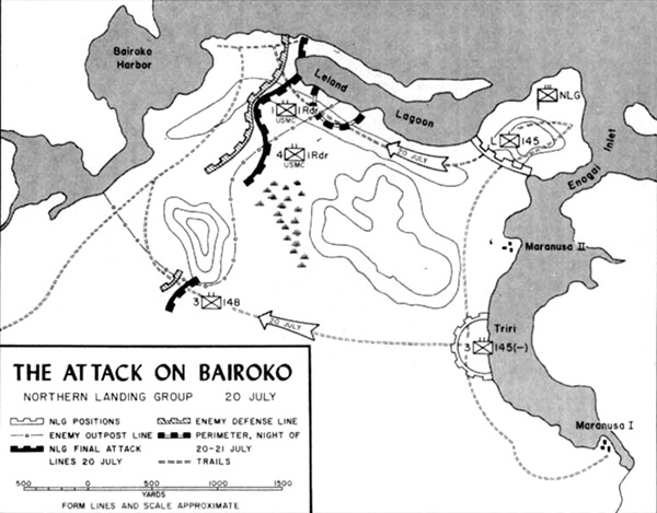
Map of The Attack on Bairoko Northern Landing Group 20 July 1943
The map indicates the U.S. Northern Landing Group (NLG) positions and Japanese defensive line and walking trails. Also annotated are locations on northern
New Georgia Island
including
Bauroko Harobr (Bairoko Harbor)
bordering
Bauroko (Bairoko)
and the
Dragons Peninsula (Dragon Point)
,
Leland Lagoon
,
Enogai (Enogai Point)
,
Enogai Inlet
, Maranusa II, Triri and Maranusa I. Also, walking trails along
Enogai Inlet
and across
Dragons Peninsula (Dragon Point)
to
Bauroko (Bairoko)
. The double dotted lines are walking trails including the Munda-Bairoko Trail.
Credit: USMC Map 9 Date:
July 20, 1943
Map
High Resolution Version
Acquire This Image
|
Contribute Information
Do you have photos or additional information?
Previous Page
Discussion Forum
Daily Updates
Reviews
Museums
Interviews & Oral Histories
Pacific Wrecks Inc.
All rights reserved.