|
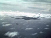
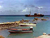
Moen Island
The island is about 6 x 8 miles in size. The Sapuk
lighthouse is to the left of the island, and the airport to the
right side.
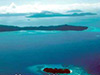
Truk Lagoon
Japanese Naval Anchorage during WWII
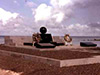
Heiwa Monument
Heiwa (Peace after
a battle) This war monument was constucted in 1980
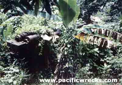
Neauo (Neuwo) Guns
The remains of bunkers and a seaplane ramp of
Moen 2 are near the Continental Hotel on the Southern tip of Moen.
You can see, that the breech has been destroyed. The brass was cannibalized
ages ago off of everything as it could be sold for big bucks, then.
1960's Japanese fishing boats grounds or pushed
by
typhoon winds into shallow water and abandoned offshore Moen between
post office & airport

C6N1 Myrt
"When I was there in 1969-70 she was
still up on her gear. By 1980 it was deteriorating fast. Clearly
a Japanese plane because of the reddish primer, while US planes
used zinc chromate."
Lighthouse (Todai)
Sapuk, Moen riddled with bullet holes from straffing USN aircraft.
|
I was invited to go to Truk in late 1969.
I had known about "Mysterous Truk" from stories I read
right after World War 2 had ended, and being interested firstly
in aviation had read everything I could find of the disappearance
of Amelia Earhart and Fred Noonan. I never met a Micronesian who
knew anything first hand about her, leading me to believe that the
rumors she had crashed near Pakin in the Ponape group were just
rumors.
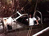
Aircraft Crashes
One thing I did learn about an aircraft crash
was to ask, where's the engine(s)? In the water or on the land,
if the engine is left where it was, it serves as a mute testimony
to the fact that an aircraft has crashed somewhere in the vicinity,
unless it was at an airport as a spare, or something like that.
Even while diving off the north side of the runway (modern airport)
of Moen, I have seen engines in the water, too far from shore to
have been just rolled into the sea to get rid of them. (See? That's
how I learned about the American Navy wreck on Eninganimu-I was
diving and shooting fish and came upon the engine in the water.
Then, I went to shore and sure enough, there was a portion of the
wing buried in the sand. Later, I spoke with the family owner of
the land, Risa, and learned of his finding the plane and pilot remains
after the war.
Moen Map
As you know, there are no street names and so
forth on islands. The usual directions are, up there, down there,
toward the mountains, and toward the sea. So, when one gets to a
new area the cardinal question one asks is, where is up there? The
direction being indicated, everything else falls into place. Hawaii
is like this too. So, I think I can draw you a verbal map, which
you can put down on paper, and while going over the way to present
it to you, I recalled another wreck site.
Make Your own Map of Moen!
Place an 8 x 10 sheet of blank paper before
you, with the long direction (11) going from left to right. The
top of the paper is West direction, Left of the paper is East. Top
of the paper points to Tol, left side of the paper points to Dublon Island (Tonoas) .At the left end, in the middle, draw a vertical line about
2 inches long, up and down. At the middle of that line, draw a horizontal
line rightward three inches long. You shud now have a letter "T"
laying on its side. Label the top of the vertical line as Neauo,
Contl Hotel, old seaplane launch ramps. Label the bottom of the
vertical line, to Wichap Village and hangar/caves. Now, at the right
end of the horizontal line you drew, draw a 1 inch vertical line
upward.
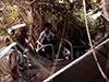
Japanese Aircraft Crash Site
At the junction of these two lines, Label Risa's
house (him being the one who discovered the crash site on Eningaminu).
Here is where there is also a crash site. Risa told me in explanation
of a large three-bladed mangled prop I saw on the ground, that there
had been an airbattle overhead, and the Japanese plane was shot
down, landing exactly where the prop still was. The next day, a
truck from the airfield came and loaded the wreckage onto it and
took it away. Pilot(s) were killed. It's a pretty good sized prop,
far larger than a Zero, but was single engine. The pilots seat,
on a pedastal, was mounted right outside Risa's hut. It was aluminum
and perforated as I recall. I sat in it. Also, part of his hut had
as a side a section of corrugated aluminum. This has zonc chromate
on it, so I suspect it is from the PBM Martins
that were caught in the 1946 typhoon.
Mwan
At the top of the last vertical line you drew
1 inch long, draw a line to the right parallel to the top of the
paper about 6 inches long. Top side of the line is seaward, bottom
side of line in mountainward. In the middle, (three inches) label
Nemete village (this is where I lived). This village is generally
known as "Mwan". One inch to the right of that, put a
mark on top of the line, label that Boat Pool. Below it on the other
side of the line, a dot labelled Post Office. One inch to the right
of the Boat Pool/Post Office mark, draw a vertical line toward you
(mountainward) three inches long. One inch down the line, a mark
on right side, label this Jail. (Ding Ding oh yes! there were Japanese
Military who lived in the tall grasses here a number of years after
the war ended without being caught. They were finally caught stealing
garbage and repatriated to Japan - No further details).
Hospital
Still coming toward you one inch from the Jail
site, draw a vertical line to the left one inch long. At end of
that line, label current hopspital. Now this hospital is on top
of a hill. At the base of this hill is where the Val is, below the
hospital. (There's an inland trail here that runs all the way back
to Nemete village where I lived. It was originally a road, and there
are lotsa places to explore along here. Barracks sites with huge
cauldrons to cook rice in and so forth. I once came across a complete
cowling from a Zero, painted black. Had the two indintation for
the 7.7mm guns on the top. It was in perfect condition, but no one
could tell me where the rest of the plane was. I was very frustrated).
There's lotsa interesting stuff around here below the hospital-it
was the terminus of the old fighterstrip and I was told the hill
the hospital sits on was actually a hangar cave and there were plane(s)
in it when the Japanese dynamited the entrance closed-what a fantasy
to break thru the seal and find intact aircraft waiting for you!!!
Now, please go back to the long horizontal 6 inch line you drew.
At the right end label it Japanese airfield, present day Continental
Air Lines airport. Nothing is to scale here. These are landmarks
only.
Spy On Truk
There was a spy parachuted in during WWII this
is an interesting story. I met a crew member on the B-24 who brought
him in from the Philippines and dropped him during the night. Can
also tell you from a lady I met the results of his spying on a group
of just-arrived aviators.
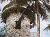
PBM Martin Seaplane Wrecks
Wreckage of two PBM Martins. They were anchored
there and during the typhoon of 1946 and were destroyed. The gull-wings
were apparent, even from 1969 thru 81. They are about 1/4 mile or
less off shore when standing directly east of them.
Return to Dick Williams Main Page
|