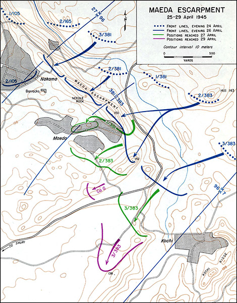
Map of Maeda Escarpment 25-29 April 1945 on Okinawa Island
Annotations include Maeda Escarpment (Hacksaw Ridge, Big Escarpment), Maeda, Highway 5 (Hwy 5), Hill 152, Hill 150, Needle Rock, Pillbox at the top of the ridge. Barracks was a a concrete building that was formally a school dubbed "Appartment House". To the southeast is Kochi and Kochi Ridge. Contour interval 10 meters.
The dotted line indicates the front lines, evening April 24, 1945 held by U.S. Army 96th Infantry Division's 3/381, 2/381, 1/381, 2/383 and 3/383.
The solid blue line indicates the front lines, evening April 26, 1945 to the crest of Maeda Escarpment and Hill 152.
The green line indicates positions reached April 27, 1945 including advance into Maeda.
The purple line indicates positions reached April 29, 1945.
Credit: U.S. Army Map No. 35 Date: April 25 ,1945–April 29, 1945
Map
High Resolution Version
Acquire This Image |
Contribute
Information
Do you have photos or additional information?
Make A Donation | Previous Page | Pacific Wrecks |