|
Location
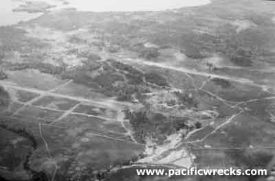
Lat 2° 34' 37S 140° 30' 59E Sentani Airfield is located to the north of Sentai inland from Hollandia (Jayapura) on the north coast of western New Guinea. Also known as "Sentani Airdrome", "Sentani Drone" or "Sentani Strip". Prewar and during the Pacific War, located in Dutch New Guinea (DNG) in the Netherlands East Indies (NEI). Between 1963-2007 part of Irian Jaya. Today located in the Jayapura Regency in Papua Province in Indonesia.
To the north was the Depopre-Aerodrome track, today a sealed road known Raya Airport Sentani (Sentani Airport Highway) and further to the north was the Cyclops Mountains. To the east is Cyclops Airfield and further east is Hollandia (Jayapura). To the southeast is Lake Sentani roughly 1.75 miles away. To the northwest was Weversdorp village. To the west is Hollandia Airfield.
Construction
Built by the Japanese as a single
runway with taxiways and a barracks area.
Wartime History
On April 26, 1944 captured by the U.S. Army 41st Infantry Division, 186th Infantry Regiment. When captured, the runway was badly cratered from
American bombing raids, and completely useless. The barracks
in the
area had also been largely destroyed. It appeared
to have not been operational for some time. Around the airfield were dozens of abandoned Japanese aircraft wrecks, several were noted and evaluated by Air Technical Intelligence Unit (ATIU) including Ki-61 Tony 966 and Ki-61 Tony 985.
Immediately, Sentani was repaired and improved by the Americans with the runway expanded to 5,000' x 115' with 300' overruns at each end and 50' shoulders, oriented ESE to WNW and surfaced with soil and gravel compacted and sealed. With accommodations and emergency equipment. Also, fuel and oil tanker trucks, weather and major repair facilities. Tower code name "Bolster". Fully developed, Sentani Airfield became a huge airbase
complex for American fighters, bombers and transports.
American units based at Sentani
475th FG, 431st FS (P-38) Nadzab May 15 - July 12, 44 Biak
475th FG, 433nd FS (P-38) Nadzab May 15 - July 14, 44 Biak
475th FG, 432nd FS (P-38) Nadzab May 15 - July 12, 44 Biak
84th Airdrome Squadron Cyclops June 20 - November 1, 1944
List of units at Hollandia area airfields
On May 21, 1944 the 84th Airdrome Squadron took over operations of Cyclops Drome and maintained sole operations of that field until June 20, 1944 when they were also given responsibility for Sentani Drome. The group remained in charge of day to day operations and maintenance at these both fields until November 1, 1944.
Postwar
By July 1, 1945 still operational, and remained in use by the Dutch administration after the Pacific War.
Today
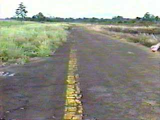
Still in use today as "Sentani Airport". Airport codes: ICAO: WAJJ IATA: DJJ. The runway is oriented 30/12 and measures 7,161' x 148' surfaced with asphalt.
John Voss visited in 1992 recalls:
"As my DC-9 was just about to touch down at Sentani
all of the taxiways and runways of Hollandia airfield
could be readily seen."
References
J-Aircraft - The Captured Oscars of Hollandia (photos)
Contribute
Information
Do you have photos or additional information to add?
Last Updated
April 19, 2021
|