|
|
|
| Missing In Action (MIA) | Prisoners Of War (POW) | Unexploded Ordnance (UXO) |
| Chronology | Locations | Aircraft | Ships | Submit Info | How You Can Help | Donate |
|
 USAAF April 1944 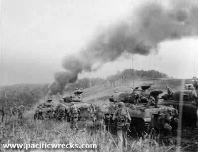 U.S. Army April 22, 1944 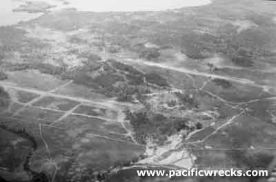 USN April 22, 1944 |
Location Lat 2° 32' 5S Long 140° 42' 20E Hollandia is located at an elevation of 341' / 103m on the north coast of western New Guinea. To the east borders Challenger Cove and beyond Humboldt Bay. To the north is Cape Soeadja. To the west is the Cyclops Mountains and beyond Tanahmerah Bay. To the southwest is Pim and beyond to the west is Lake Sentani. Prewar and during the Pacific War, located in Dutch New Guinea (DNG) in the Netherlands East Indies (NEI). On October 1, 1962 renamed Hollandia Kota Baru (Hollandia New Town) while jointly administered by the Dutch and Indonesians. On May 1, 1963 renamed renamed Sukarnapura by Indonesia honor of President Sukarno. In 1968 renamed Jayapura. Also known as Jaya Pur or Kota Jayapura. Between 1963-2007 part of Irian Jaya. Today known as Jayapura Kota (Jayapura City) located in Jayapura Regency in Papua Province in Indonesia. Prewar Prior to European contact, a Melanesian settlement named Numbay was at this location near the mouth of the Numbay River that empties into Humboldt Bay. On September 28, 1909 a Dutch navy vessel commanded by Captain F. J. P. Sachse landed at Humboldt Bay near the mouth of the Numbay River and established a camp named Kloofkamp at this location. On March 7, 1910 the Dutch established a settlement at this location that they named Hollandia and from this location administered Dutch New Guinea. Wartime History During April 1942 occupied by the Japanese Army. The Hollandia area was developed into a base area with three airfields: Hollandia Airfield, Sentani Airfield and Cyclops Airfield with Tami Airfield further to the east. During April 1943 until April 1944, targeted by Allied aircraft, the airfields were neutralized by the middle of April 1944. American missions against Hollandia April 17, 1943–April 25, 1944 By early 1944, the Japanese garrison at Hollandia consisted of the remnants of the Japanese Army 41st, 20th and 51st Divisions with many support and air personnel. During March 1944, a reconnaissances party was landed by submarine USS Dace SS-247. Two groups were landed which included US Army CIC, Australian, Indonesian and four New Guinea natives: Mariba, Yali, McNicol and Buka. Only 7 of the 12 landed were recovered, but revealed a weak Japanese presence in the area. General MacArthur planned a daring leapfrog operation to bypass stronger Japanese garrisons along the north coast of New Guinea for a landing further to the west at Hollandia which was weakly defended in an operation aimed at capturing the airfields in the area and development of Hollandia into a base for future operations including the liberation of the Philippines. Battle of Hollandia On April 22, 1944 an American amphibious task force code named "Operation Reckless" landed U.S. Army troops at Humboldt Bay and Tanahmerah Bay near Hollandia. Meanwhile, "Operation Persecution" the amphibious task landing at Aitape is undertaken protect the eastern flank. The landing is primarily by troops from the U.S. Army 41st Infantry Division. They are supported by M4 Shermans from the United States Marine Corps (USMC) 1st Marine Division, 1st Tank Battalion, Company A but a swampy area beyond the beachhead limits their effectiveness. Japanese were caught by surprise and weakened by aerial attacks and bombardment and offered little resistance. In the landing area, many Japanese who were starving or rear echelon troops were willing to surrender unlike in earlier landings and battles. The remaining Japanese retreated inland and attempted to escape westward. Advancing, the Americans encountered faced muddy conditions, swamp and jungle that made the drive inland difficult. After the battle the Hollandia area was immediately repaired and developed into a major U.S. Army base and staging area for future operations including the landings at Biak, Leyte and Luzon. Hollandia was designated "Base G" by U.S. Army letter base designation. Hollandia remained an important American base until the end of the Pacific War. During late April 1944 until the end of the Pacific War, designated U.S. Army as Army Post Office 565 (APO 565).
Postwar During 1945, Hollandia was designated as the capital of Dutch New Guinea. On October 1, 1962 renamed Hollandia Kota Baru (Hollandia New Town) when jointly administered by the Dutch and Indonesians. On May 1, 1963 renamed Sukarnapura in honor of Indonesia President Sukarno. In 1968 renamed Jayapura. Today, it is the largest city in Jayapura Regency in Papua Province in Indonesia. Tanahmerah Bay (Red Beach) Several US tanks hulks lie to the east of Depapre at the base of the track built be the Americans that connects Tanahmerah to Jayapura (Hollandia) to the East. Following a Navy bombardment, elements of the 24th Infantry Division, 19th and 21st Infantry Regiments landed at "Red Beach 1" and "Red Beach 2". Humboldt Bay (White Beach) Natural harbor located to the East of Hollandia town. The 41st Infantry Division landed against light opposition on April 22, 1944. After the invasion, the bay became a major American staging base, for future landings in the Philippines. Cyclops Airfield and mountain near Hollandia, MacArthur's HQ at Hollanida. Sentani Located inland from Hollandia, site of Sentani Airfield, parallel, to the south Cyclops Drome. Also, Lake Sentani a large freshwater lake. Museum Jayapura Located inside the Cenderawasih University campus. Hollandia Area Airfields Hollandia Airfield (Hollandia Drome) located furthest to the west of Hollandia Sentani Airfield (Sentani Drome) located to the north of Sentani and Lake Sentani Cyclops Airfield (Cyclops Drome) located to the west of Hollandia Tami Airfield (Tami Drome) located to the east of Hollandia at Tami Contribute
Information Last Updated
|
Map April 22, 1944 July 1945 Map Fallingrain |
| Discussion Forum | Daily Updates | Reviews | Museums | Interviews & Oral Histories |
|