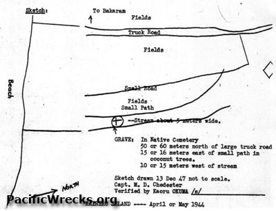
Map of the grave location of 2nd Lt. Robert Eric Thorpe executed May 31, 1944 near St. John's Mission on Kairiru Island
The map is annotated with the beach on the southern coast of Kairiru Island near Bakaram (St. John's Mission) including truck road, fields, small road, fields, small path and stream about 5 meters wide.
The map includes the typed notation:
"Grave: In Native Cemetery
50 or 60 meters north of large truck road 15 or 16 meters east of small path in coconut trees. 10 or 15 meters west of stream
Sketch drawn 13 Dec 47 not to scale.
Capt. M. D. Chedester
Verified by Kaoru Okuma /s/
Kairiru Island --- April or May 1944"
Credit: War Crime Testimony Date: December 13, 1947
Map
High Resolution Version
Acquire This Image |
Contribute
Information
Do you have photos or additional information?
Make A Donation | Previous Page | Pacific Wrecks |