|
|
|
|
| Missing In Action (MIA) | Prisoners Of War (POW) | Unexploded Ordnance (UXO) |
| Chronology | Locations | Aircraft | Ships | Submit Info | How You Can Help | Donate |
|
   Justin Taylan 2003 |
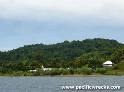
Location Lat 3° 21' 0S Long 143° 34' 0E Kairiru Island is located off the north coast of New Guinea to the north of Wewak. Pronounced "Kai-ri-ru". Sometimes mispelled as "Kairuru", "Kairiri" or "Kairir" in some references. Also known as D’Urville Island. The island is 40km in circumference and at roughly the center is Mount Malangis a dormant volcano. To the west borders Victoria Bay. To the south borders Kairiru Strait and beyond Mushu Island. To the north is the Bismarck Sea. Prewar and during the Pacific War located in the Territory of New Guinea. Today located in Wewak District of East Sepik Province in Papua New Guinea (PNG). Wartime History During December 1942, occupied by the Imperial Japanese Navy (IJN) and the southern coast between Saint John's Mission (Barakam, Bagaram) to Yavik (Yauik, Yarin) was developed into a base area, seaplane base and anchorage area. The area was defended by radar and naval guns. Starting in early April 1943 attacked by Allied bombers and fighters until late August 1944. Allied missions against Kairiru April 10 1943–August 27, 1944 Between September 1943 to April 1945, Japanese Navy personnel on Kairiru Island were responsible for the detention, interrogation, torture and execution of at least eight Allied Prisoners Of War (POW) including six American and two Australian in the vicinity of Saint John's Mission. Occupied by the Japanese for the duration of the Pacific War. On September 10, 1945 Rear-Admiral Sato boarded ML 805 in the Kairiru Strait and surrendered the remaining Japanese Navy forces under his command on Muschu and Kairuru by handed over his sword to Australian Army Major-General Robertson, commander of the 6th Division. Three days later, the Imperial Japanese Army (IJA) garrison surrendered at Cape Wom. Postwar The first repatriation of the Japanese from Kairiru occurred on December 26, 1945 when the Koei Maru took several hundred Japanese from Kairiru back to Japan. Saint John's Mission (Saint John's Mission, Barakam, Bagaram) This Catholic mission was built prior to the war, it faces southwards, overlooking nearby Mushu Island. St. John's Mission was used as the Japanese Navy headquarters on Kairiru and also as the shore facilities for Kairiru Seaplane Base. On March 21, 1944 the mission was largely destroyed by American bombing. Postwar, it was rebuilt and today, still functions as a Catholic Mission. Also known as St. John's Mission. St. Xaviar Mission / High School Located halfway down the island, on the southern coast. Prior to the war, this was a Catholic mission. Today St. Xaviar High School is a high school for students on Kairiru Island. A Japanese Memorial is located at the school. Until at least 1969, the tail section of a Ki-43 Oscar remained near the school. Kevin Fitzpatrick recalls: "In 1969, there was a delegation from the Japanese Military, who came to Kairiru to exhume, and give a proper burial to Japanese soldiers who had died on the island during WWII. The sites where Japanese soldiers lay interred were remembered by the locals, and thus the remains were recovered." Japanese Memorial A small Japanese memorial with 13mm machine gun is located on the grounds of the school. Its plaque reads in English and Japanese: "1942 - 1945 Dedicated to those men of the Japanese navy who died serving their country in New Guinea." Yuwun Located on the southern coast of the island, towards the eastern tip. There is a landing area here in a small sheltered cove. During the war, the Japanese No. 4 Company was based at this location. Mobile Radar Unit The rusted hulk of a radar trailer are on the beach. Part of the metal frame screen is used as a 'bridge' on the pathway above the beach. Reportedly, this radar was mounted up on the hill above Yavik along with a search light, It was partially recovered for scrapped by Emil Claus. Tunnels Several caves used by the Japanese, that were dug by local labor with only hand tools. Tunnels, usually smaller L-shapes or with interconnecting entrances are common around the south of the island. Yavik (Yarin) Located on the southeastern tip of Kairiru Island, surrounded by high cliffs Victoria Bay Deep water bay located at the western edge of the island. Two shipwrecks sunk by air attack the bay including the Taisei Maru, an unidentified Japanese merchant ship. P-47D Thunderbolt Serial Number 42-22661 Pilot Thorpe ditched May 27, 1944 north of Kairiru Island, pilot captured and executed May 31, 1944 P-47D "Fiery Ginger III" Serial Number 42-75908 Pilot Ness MIA October 22, 1943 Contribute
Information Last Updated
|
Map 1956 Map Fallingrain Map Mapcarta Photo Archive |
| Discussion Forum | Daily Updates | Reviews | Museums | Interviews & Oral Histories |
|