|
|
|
|
| Missing In Action (MIA) | Prisoners Of War (POW) | Unexploded Ordnance (UXO) |
| Chronology | Locations | Aircraft | Ships | Submit Info | How You Can Help | Donate |
|
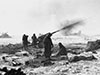 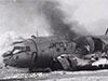 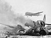 USMC December 6, 1950 |
Location 40°22'1"N 127°16'1"E Hagaru-ri Airfield is located to the east of Hagaru-ri off the southern tip of the Chosin Reservoir (Changjin) in in South Hamgyŏng Province in Democratic People's Republic of Korea (North Korea). Connected by road to Sinhung-ni to the west, Hudong-ni to the northeast, Yudam-ni to the northwest and Hell Fire Valley and Kot'o-ri to the south. Construction During late November 1950 American forces constructed a rough emergency airfield was built at this location, completed by December 1, 1950. Korean War Used by United Nations (U.N) forces during the Battle of the Chosin Reservoir as a forward airfield primarily for evacuating the wounded and for airlifting critical supplies to the area. R4D-6 Dakota 50767 Pilot Noel damaged December 1, 1950 destroyed December 6, 1950 Today After the war, expanded into a single sealed runway running roughly NNW to SSE. Still in use as a North Korean military airfield. Today known as "Changjin-up Airfield" or "Changjin-up Airbase" or "Chosin Airbase". References Wiikimapia - Changjin-up / Chosin Military Airbase Contribute
Information Last Updated
|
Map Fallingrain Map 1951 |
| Discussion Forum | Daily Updates | Reviews | Museums | Interviews & Oral Histories |
|