|
|
|
|
| Missing In Action (MIA) | Prisoners Of War (POW) | Unexploded Ordnance (UXO) |
| Chronology | Locations | Aircraft | Ships | Submit Info | How You Can Help | Donate |
|
 USAAF Feb 21, 1944  Sagnik12 2012  WW2 Talk 2012 |
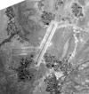
Location Lat 22° 50' N Long 88° 37' E Baigachi Airfield was located northeast of Baigachi in West Bengal State in India. Located to the south of a lake and northwest of Maniknager, roughly 25 miles from Calcutta. Construction Built by the British. This airfield had two intersecting runways one NE/SW measuring 6,000' x 150' and a smaller E/W measuring 4,800' x 600'. A tarmac connected the two strips. Facilities included a radio transmitter, direction finder, control tower and air to ground radio and wind sock. At least four "sun pens" were built for servicing aircraft. Wartime History Used by the Royal Air Force (RAF) as a fighter airfield. On December 26, 1943 on a reconnaissance mission, Ki-46 Dinah 5004 overflew Baigachi and was shot down. RAF units based at Baigachi No. 152 Squadron (Spitfire) Today Disused since the war. Today, part of the Ashoknagar-Kalyangarh municipality. At the former airfield, four "sun pens" for servicing aircraft remain in situ at the former airfield. References RAF Web - RAF Baigachi USAAF "Pilot's Handbook: Karachi to Chittagong Supplementary Airports" Baigachi India Contribute
Information Last Updated
|
| Discussion Forum | Daily Updates | Reviews | Museums | Interviews & Oral Histories |
|